
Fire Lookouts and The Mountaineers
PiLCHUCK | THREE FINGERS | HEYBROOK
Most people don't realize it but many of Washington State's historical fire lookouts are maintained by volunteers. The Everett branch of The Mountaineers help maintain and make sure that these three lookouts in the North Cascades are taken care of and can be enjoyed by future generations to come.
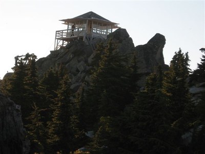
Three Fingers Lookout
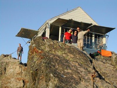 In the mid-1980s, The Everett Mountaineers restored the lookout on the southern summit (6,850') of Three Fingers. Three Fingers photo collection #1 and collection #2.
In 2014, the roof was replaced. In 2025, we replaced floor supports, siding and gable trim. For 2026, we will be replacing the iconic ladders that provide access up the final rock face approach.
Three Fingers lookout is on the National Register of Historic Places. During restoration in 1986, these photos were submitted to the National Park service .
The lookout is a 14x14 type L-4 lookout
Getting there
Note: Some of the roads have been washed out in recent years. Please check with the forest service for latest conditions.
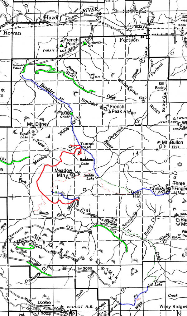
Historical Maps of Three Fingers
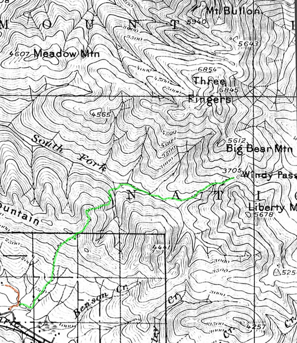
The USGS Stilaguamish, 30', 1899 map does not show any lookouts (Mt. Pilchuck, Three Fingers, Higgins, or French Creek) and the only trail near Three Fingers goes to Windy Pass. Note the older spelling of Stillaguamish. The Northern Pacific Railroad, Monte Cristo spur can be seen in the valley. There is no road up the South Fork of the Stillaguamish. There is at least one more long abandoned trail shown on the map. Are there others?
The USGS Stillaguamish, 30', 1946 map is not much different than the 1899 map. There is no lookout.
The USGS Silverton, 15', 1957 map shows the Three Fingers Lookout but no trail! Gone is the railroad and the Mountain Loop Highway runs up the South Fork of the Stillaguamish. Logging roads appear to the south of the river. The trails up Wiley Creek and Eldred Creek may not currently exist. The trail running south from Sunnyside Camp may now be a road. The other trails appear to exist today but some have been shortened by roads.
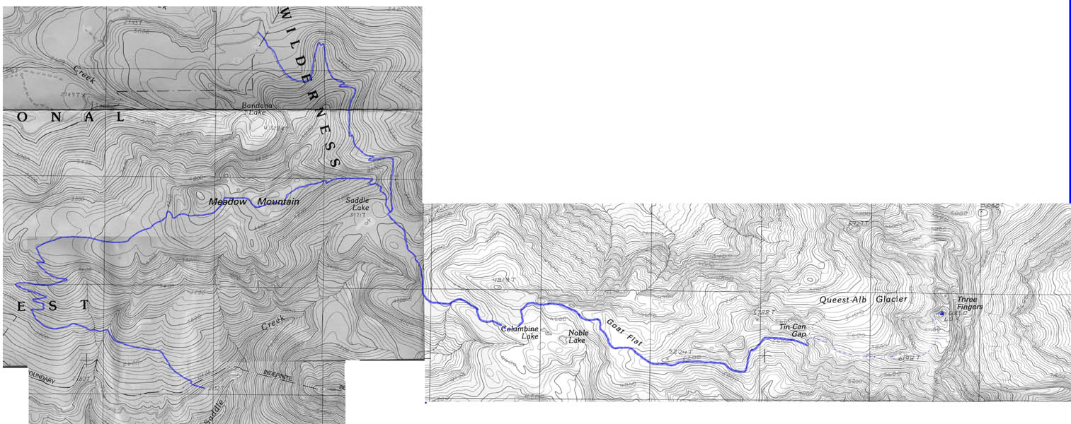
The USGS Whitehorse and Meadow Mountain, 7.5', 1989 maps were combined to show the trail-route to Three Fingers. Past the maintained trail (solid line), dashed lines represent the very approximate route to the Lookout based on eight-year old memory.
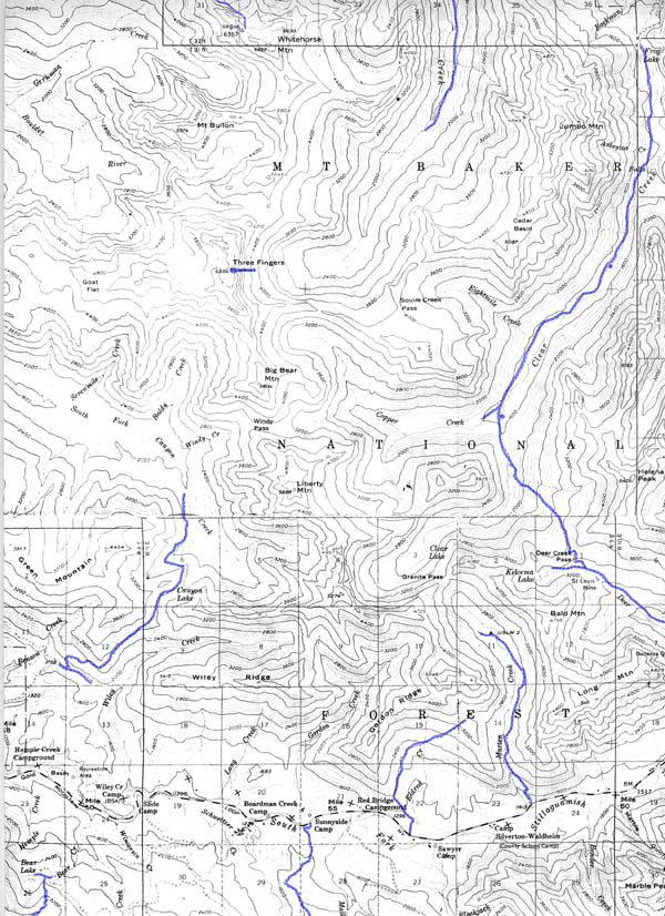
A composite of USFS Mt.Baker-Snoqualmie National Forest maps, 1962 and 1989
History of lookout maintenance
First article in the Everett Mountaineers Newsletter on repair efforts appeared September, 1986.
Mount Pilchuck Lookout
 Only 20 miles from downtown Everett, Mount Pilchuck (5,324 ft) is right in our back yard. A very popular trail heads up from the former skiers parking area. Washington State Parks and The Everett Mountaineers maintain the historic lookout building. We coordinate volunteers to maintain of Pilchuck Lookout. In 1989, the Everett Mountaineers restored the building. 105 people spent 10,000 hours, with help from Snohomish County Search and Rescue and Army Reserve helicopters. Everett Branch Chair Larry Longley first proposed to save the dilapidated lookout which was scheduled to be burned down the following winter, then spent countless hours researching, coordinating, and getting the project selected as one of the state's official Centennial Celebration projects before spending countless hours up at the lookout with Stan Koska, the construction supervisor.
Getting there
From Everett, drive US-2 east toward Lake Stevens. Go north on US-9 at Frontier Village and then right (east) on SR-92 toward Granite Falls. At the east end of Granite Falls find the Mountain Loop Highway (MLH). From Granite Falls follow the MLH east. One mile beyond the Verlot Public Service Center, turn right onto graveled Forest Road 42 immediately after crossing the "Blue Bridge." Drive 7 miles to the trailhead at the road end (3,100 ft). Privy available.
The trail heads to the lookout. Caution: Snow stays on the northern exposures until late spring-summer. Some areas are dangerous to those without proper equipment and training.
History of Mount Pilchuck lookout building
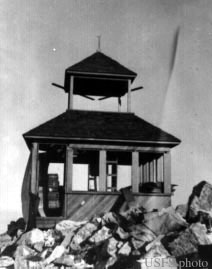 Mount Pilchuck in the olden days, USFS
Various references conflict on the history of the building:
- Mount Pilchuck was first climbed in 1897 by Louis Fletcher of the USGS. The first ascent took 8 hours from the Monte Cristo Railroad -- there was no trail! Trail built 1918. 12 feet of the top was blasted off for the lookout. First lookout building 1919, rebuilt in 1942 and manned until 1956. Airplanes hit the mountain in 1948, 1952, and 1964 3.
- Built 1921 with cupola, rebuilt 1938 as an L-4 cabin, abandoned 1961 2.
- Built 1918 "through the Herculean efforts of those days, with materials hand-winched up rocky cliffs". 1
In 1989, The Everett Mountaineers played a key role in renovating the building.
It's fascinating to read about the life of the lookouts on Mount Pilchuck. "Pilchuck, the Life of a Mountain", by Larrison and Higman (1949) documents some of the post-WWII era. From 1957 to 1979 there was a ski area, but it proved to have poor snow quality.
Historic Pilchuck Maps
This progression of USGS and USFS maps show the historical development around the lookout. Colors have been used to highlight select, man-made features of interest.
- Blue = items spanning the years.
- Lime green = items missing in later years.
- Red = items appearing in later years.
- Brown = trails or railroads that become roads (after a fashion).
- Purple = trails that are known to exist but are missing on the maps (locations approximate).
The USGS Stilaguamish, 30', 1899 map does not show the lookout because it hadn't been built. Note the early spelling of Stillaquamish. The Northern Pacific Railroad, Monte Cristo spur can be seen in the Stilaguamish valley. The road up the South Fork of the Stilaguamish ended before Gold Basin (a real place then). Most curious is the absence of Lake 22 at the head of Twentytwo Creek. On modern maps it is at least twice as big Pinnacle or Bear Lakes. Was a damming in its future?
The USGS Stilaguamish, 30', 1946 map is not much different than the 1899 map. The railroad is now abandoned. Lake 22 is now on the map but it is tiny. Actually, Lake 22 first appeared on the 1901 reprint of the 1899 map.
The USGS Granite Falls, 15', 1956 map shows the Mt. Pilchuck Lookout and two trails to it! The one in green is the long lost trail to the Sultan Basin. Gone is the railroad; now the Mountain Loop Highway runs up the South Fork of the Stillaguamish. Logging roads appear to the south of the lookout and to the northwest. Look how Lake Twentytwo has grown to its current size. Verlot now is a place. The one red logging road is symbolic of the numerous roads currently on the west side of the summit.
USGS Verlot, 7.5', 1989 map shows the lookout and only one trail to it. Some time between 1956 and 1989, the Mt. Pilchuck Ski Resort came and went with the scarcity of trees to the NNW of the summit being its legacy. The current trail slightly deviates from that shown on the 1989 map. Portions of the trail were re-routed in the 2000-2001 to reduce erosion.
A composite of USFS Mt.Baker-Snoqualamie National Forestmaps, 1962 and 1989 .
Heybrook Lookout
Heybrook Lookout is on Heybrook Ridge just east of the town of Index. Mt. Index is the predominate view from the lookout. The committee wrapped up an eight year-long project in 2002. Hundreds of volunteer hours, and thousands of dollars were donated by businesses and organizations, to restore the lookout, which sits at the top of a 70-foot tower.
Getting there
From Everett, follow US 2 east for 37 miles (approximately 2 miles east of the steel bridge crossing the Skykomish River) to the trailhead (elev. 850 ft), located on the north side of the highway just after entering Mount Baker-Snoqualmie National Forest. (WTA hiking guide for Heybrook trail)
Follow the 1.3 mile maintained trail, gaining ~850' to the lookout.
Heybrook Lookout History
At first, the fire lookout would stay in a tent on a small tower 2. The first building in 1925 was a platform tower, then in 1932 a 45 foot L-4 cabin was built, and in 1964 a 67 foot TT flat was built 1. The original lookout was designed by Dan Evans, former governor of Washington State 4.
The Everett Mountaineers started working on Heybrook Lookout in 1996 under a Challenge Cost Share Agreement authorized by Marcia Hanson (Mountaineer President) and Dennis Bachor (Forest Service Supervisor). LOTM tore down the dilapidated lookout hut on top of the tower at Heybrook and then built a new hut in the parking lot of the Skykomish Ranger Station using the original plans. The hut was disassembled, transported to the Heybrook site, hoisted up to the top of the tower, and then reassembled. The restoration project was successfully completed by the end of 2002. Notification of Work Completion: January 12, 2003.