
Everett Lookout & Trail Maintenance Committee
Committee volunteering
In 1929, Harold Engles, district ranger, climbed the middle-peak of Three Fingers mountain to site a fire lookout. The construction occurred between 1930 and 1932. In 1972, Harold Engles and the Mountaineers led by Kenn Carpenter, replaced broken ladders, roof supports and window panes at the cabin. In 1985, the LOTM committee was formed to officially take over routine maintenance of the Three Fingers lookout.
If you're passionate about stewardship and helping maintain infrastructure that so many Mountaineer activities depend on, join our committee! We'd love to have you!
Here are the steps to become a crew leader with us
Your knowledge, skills, and abilities will be evaluated by a crew leader with our KSA checklist. We will present and explain each item during the mentored activities.
As a crew leader, you will lead trips that are commensurate with your skill level. Usually starting with brushing and tread work.
We also could use help running other committee business. You don't need to be a crew leader to help out stewardship. Let us know if this interests you.
Our monthly meetings are open to all members and guests and posted on the Everett events calendar. Usually on the second Tuesday of the month. You can opt-in here for updates and committee agendas.
Trail Maintenance
.jpg") In addition to lookout restoration and maintenance, The Everett Mountaineers has been active in trail maintenance for many years. Working originally with the U.S. Forest Service in small groups of volunteers, clearing popular trails of brush and replanting trampled meadows bordering alpine lakes.
In addition to lookout restoration and maintenance, The Everett Mountaineers has been active in trail maintenance for many years. Working originally with the U.S. Forest Service in small groups of volunteers, clearing popular trails of brush and replanting trampled meadows bordering alpine lakes.
The LOTM Committee has sponsored and coordinated work parties to commemorate National Trails Day. The branch's efforts on National Trails Day has won the respect of non-profit organizations and land management agencies, while improving the quality of designated trails, and constructing new ones.
Three FIngers Lookout
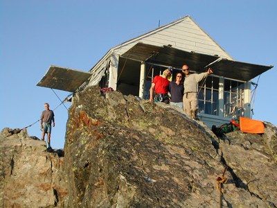
In the mid-1980s, The Everett Mountaineers restored the lookout on the southern summit (6,850') of Three Fingers.
Three Fingers lookout is on the National Register of Historic Places. During restoration in 1986, these photos were submitted to the National Park service .
The committee is involved with FS41 road and trail maintenance for both Meadow Mt and Tupso pass trails as well as maintaining the structure.
Important trip planning information can be found at Three Fingers current Info
Learn more on the lookout history and info page.
Mount Pilchuck Lookout

Only 20 miles from downtown Everett, Mt. Pilchuck (el. 5,324') is right in our back yard. A very popular trail heads up from the former skiers parking area. Historically, Washington State Parks and The Everett Mountaineers have maintained the historic lookout building. We have coordinated volunteers to maintain of Pilchuck Lookout. In 1989, the Everett Mountaineers restored the building. 105 people spent 10,000 hours, with help from Snohomish County Search and Rescue and Army Reserve helicopters.
In 2025, The Mountaineers have resumed our stewardship activities along with WA State Parks to maintain the Pilchuck Lookout.
Learn more on the lookout history and info page.
Heybrook Lookout
Heybrook Lookout is on Heybrook Ridge just east of the town of Index. Mt. Index is the predominate view from the lookout. The committee wrapped up an eight year-long project in 2002. Hundreds of volunteer hours, and thousands of dollars were donated by businesses and organizations, to restore the lookout, which sits at the top of a 70-foot tower.
Learn more on the lookout history and info page.
Lord hill regional park

LHRP is a 1,480-acre park located in central Snohomish County between the cities of Snohomish and Monroe. Set in former timberland, the park offers approximately 30 miles of trails where visitors can traverse uphill and downhill through the forest passing wetlands and ponds dotted throughout the landscape. The park is popular with hikers, runners, equestrians, mountain bikers, wildlife watchers, orienteering groups, nature enthusiasts, educators and more. As one of the largest parks in our county parks system, Lord Hill Regional Park is an important park for not only the county, but the greater Puget Sound region.
Lime Kiln Trail
The Lime Kiln trail is on a route used from 1892 to 1934. The 3.6 mile trail was opened in 2007 by volunteer labor including the Everett Mountaineers. The Everett and Monte Cristo railroad traveled part of the trail, and the lime kiln provided needed material for the Everett Smelter and paper mills. From the trailhead to the river is about one and a half miles. From there to the Lime Kiln is just over a mile, and then it is about a mile from the kiln to the end of the trail, where the river takes a sharp bend to the south. Over a hundred years ago, the E&MCRR continued across a bridge, through tunnel #1 (a.k.a. "The Kissing Tunnel"), and on to the ghost mining town Monte Cristo.
Note: check with Snohomish county to make sure the trail is open.
LOTM worked on this long-abandoned trail on National Trails Day, 2001. See photos of the work.
Getting there
Maps: USGS Granite Falls, 1989, Green Trails Granite Falls.
History
Not surprisingly, the Lime Kiln "trail" was established by operators of a lime kiln a long time ago. Some of the route is the old railroad route to Monte Cristo. Please don't disturb the artifacts. Robe Canyon history has more information.
Historic Maps of the Lime Kiln area
A progression of USGS and USFS maps show the historical development around the kiln. Colors4 have been used to highlight select, man-made features of interest.
A USFS Mt.Baker-Snoqualamie National Forest>map of 1962 shows a trail appears to go to some building near the kiln but doesn't seem to be close to the current trail.
The USGS Stilaguamish, 30', 1899 map has trails all over the place going to cabins? Note the older spelling of Stillaguamish. The Northern Pacific Railroad, Monte Cristo spur can be seen in the valley. Pilchuck was a fork in the road along Purdy Creek. The city of Granite Falls was not quite as big as it is now.
The USGS Stillaguamish, 30', 1946 map is not much different than the 1899 map.
By 1956, everyone in those cabins must have moved to Granite Falls, as the city is bigger and the cabins are gone in the USGS Granite Falls, 15', 1956 map. Wayside mine on the north side of Iron Mountain seems to become an open pit quarry by 1989. In none of the historical maps is the location of the Lime Kiln apparent.