Field trip: Winter Trail Running Conditioning Series
Morning: February Winter Conditioning Run: 6+ miles - Licorice Fern Trail & Far Country Lookout
Winter Trail Running Conditioning Course runs from 6+ miles. You will need to complete 2 course runs per month over Dec, Jan and Feb to graduate.
- Sun, Feb 25, 2024
- Foothills Trail Running Committee
- Trail Running
- Adults
- Easy/Moderate
- Easy
- Mileage: 7.5 mi
- Elevation Gain: 1,539 ft
- High Point Elevation: 1,436 ft
- Pace: avg 3.5 mph
- 5 (8 capacity)
- FULL (2 capacity)
- Mon, Jan 15, 2024 at 8:00 AM
- Fri, Feb 23, 2024 at 5:00 PM
- Cancellation & Refund Policy
- iCal Google
This route will cover several Cougar trails, starting at Licorice Fern in Newcastle.
We will follow a clockwise lollipop loop for ~7 1/2 miles total distance with 1,539 ft elevation gain, covering several Cougar trails. We will stop periodically as needed for hydration and snacks. We will look to do an avg pace of 3.5 mph: moderate hike uphill and 4.5-5.0 mph straighaway and downhill. Even though we are starting mid-afternoon, please bring headlamp just in case we finish in the dark!
For a complete description of trail running with the Mountaineers, please consult the Trail Running Standards.
King County Cougar Map: https://your.kingcounty.gov/GIS/web/Web/VMC/recreation/BCT_CougarMtn_brochure_.pdf
Full details will be soon after registration closes on Feb 23. In the interim, please contact the leader with any questions at travisj.prescott@gmail.com.
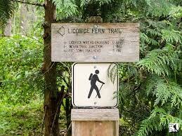
Meet at 2:00 pm at Licorice Fern trailhead, which begins directly from 169th Ave SE. Look for a small hiker sign indicating the trailhead. Parking on street - no passes required. Following introductions, description of route and current trail conditions, plan to start running by 2:10 pm. There are no public bathrooms at the trailhead or anywhere along the route.
Directions:
From Seattle, take I-90 East to exit 15 and make a right onto 17th Ave, which later becomes Renton/Issaquah Road. Drive for about four miles, then turn right onto SE May Valley Rd. Shortly after, make a sharp right onto SE 112th St. This road soon becomes 169th Ave SE as it turns left. The trailhead will be on that curve, on your right hand side--look for the hiker sign. Park along 169th Ave.
From I-405, exit onto Coal Creek Pkwy. Head
south to May Valley Rd. Turn left and continue 2.3 miles,
merge onto SE 112th St, then turn left onto 169th Ave SE.
Required Equipment
Please wear layers of breathable, technical clothing suitable for outdoor aerobic activities for this course's activities.
- Waterproof jacket, hat, buff, gloves, sunglasses; running-specific gaiters recommended
- Warm mid-weight layer (e.g. down vest or wool long sleeve)
- Trail running shoes
- A small day pack suitable for trail running
- Bring snacks and water
- Trail running-adapted ten essentials
- Headlamp with spare batteries
