Field trip: Conditioning Hiking Series
CHS 2 Hike - Fragrance & Lost Lakes
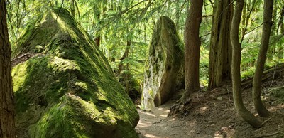
Come join us on a hike in beautiful Larrabee State Park – Washington’s first state park. Hike will include the amazing Rock trail. CHS hike led at a CHS 2 pace (2.0-3.0 mph)
- Sat, Jun 3, 2023
- Seattle Hiking Committee
- Day Hiking
- Adults
- Moderate
- Moderate
- Mileage: 10.5 mi
- Elevation Gain: 2,000 ft
- Pace: 2.0-3.0 mph
- FULL, 3 on waitlist (10 capacity)
- Wed, May 24, 2023 at 1:00 PM
- Thu, Jun 1, 2023 at 5:00 PM
- Cancellation & Refund Policy
- iCal Google
We will hike via the Fragrance Lake Trail to Fragrance Lake looping around the small lake. Then we’ll head to the Cyrus Gates Overlook (there are bathrooms) before heading down the truly amazing Rock trail. We will continue onto the Lost Lake trail - hiking until we find a good lunch spot. After lunch, we will return to the trailhead via the Lost Lake and Fragrance Lake trails.
We will likely stop in Bellingham for lunch before heading south to the Ash Way Park & Ride.
***
Notes on the Rock Trail portion completed by WTA around 2015.
“While unusual sandstone formations are common at Larrabee State Park, hikers typically find them near the beach. But the cliffs on the Rock Trail are interesting because they share characteristics with the seaside rocks, despite being far removed from the shoreline.
After exploring the imposing rocks, keep heading down through moss and licorice ferns, crossing a creek via "Bogaards Bridge", named for the WTA crew leaders who helped make the trail a reality. Be sure to look up and out as you hike; on clear days, Mount Baker and the Twin Sisters glide into view just past the bridge.
Continuing down, hikers clamber down three steep sets of stairs and wind through three more switchbacks until the trail flattens out. A huge boulder to the right of the trail, about three-quarters of a mile in, hides an interesting cave for exploring.
From here the junction with the South Lost Lake Trail is quite close. Press on, and note how high the trees soar above your head! At the overlook, you could see over the tops of some of the trees whose bases you're now walking by.”
We will meet at the Ash Way Park & Ride in Lynnwood at 7:00 am. It should take around 75 minutes to drive to Larrabee State Park. We plan to start the hike at 8:30 am.
The Ash Way Park & Ride is located at 16327 Ash Way in Lynnwood. The group will meet inside the main entrance on the Ash Way side.
Directions to the park & ride from n/b I-5 – take exit # 183 for 164th St SW, left across the freeway and right onto Ash Way.
Fragrance & Lost Lakes
-
USGS Bellingham South
Trails of the Chuckanut Mountains
Chuckanut Mountain Recreation Map - See full route/place details.
Required Equipment
Ten Essential Systems
- Navigation (map & compass)
- Sun protection (sunglasses & sunscreen)
- Insulation (extra clothing)
- Illumination (headlamp/flashlight)
- First-aid supplies
- Fire (waterproof matches/lighter/candle)
- Repair kit and tools
- Nutrition (extra food)
- Hydration (extra water)
- Emergency shelter (tent/plastic tube tent/garbage bag)

