Field trip: Conditioning Hiking Series
CHS 1 Hike - Grand Ridge (Olympics)
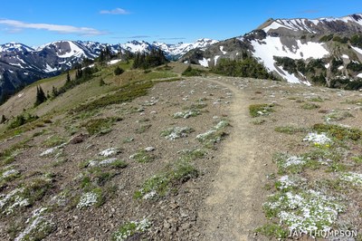
Grand Ridge is the highest continuous trail in the Olympic Mountains. On a clear day it's among the most beautiful places in Washington; the 360º view includes the interior of the Olympics, the Strait of Juan de Fuca, Canada, and the Cascades. THIS IS A KEY-EXCHANGE HIKE with a CHS2 group. We start at Deer Park TH, end at Obstruction Pt TH. BE AWARE that at least 1 participant will need to drive to Deer Park TH and that someone from the CHS2 group will drive that vehicle back to the campground.
- Sat, Aug 10, 2024
- Seattle Hiking Committee
- Day Hiking
- Adults
- Strenuous
- Moderate
- Mileage: 10.0 mi
- Elevation Gain: 3,000 ft
- Pace: 1.5-2.0 mph avg moving pace
- 6 (6 capacity)
- 2 (2 capacity)
- Wed, Jul 17, 2024 at 9:00 AM
- Thu, Aug 8, 2024 at 5:00 PM
- Cancellation & Refund Policy
- iCal Google
- Deer Park TH, time TBD
- Weather - from NWS
- Route - https://caltopo.com/m/AF701 includes both Blue Mountain and Grand Ridge
- Directions from WTA - Drive U.S. 101 from either Port Angeles or Sequim to the Deer Park Road, near milepost 253. Drive 9 miles of paved road and then 8 miles of rough (although suitable for all vehicles) gravel road with scary dropoffs. Turn right toward the ranger station and park in the tiny lot.
Grand Ridge (Olympics)
-
Green Trails Hurricane Ridge/Elwha North No. 134S
Custom Correct Hurricane Ridge
Trails Illustrated Olympic National Park
Green Trails Mt Angeles No. 135 - See full route/place details.
Required Equipment
Ten Essential Systems
- Navigation (map & compass)
- Sun protection (sunglasses & sunscreen)
- Insulation (extra clothing)
- Illumination (headlamp/flashlight)
- First-aid supplies
- Fire (waterproof matches/lighter/candle)
- Repair kit and tools
- Nutrition (extra food)
- Hydration (extra water)
- Emergency shelter (tent/plastic tube tent/garbage bag)
