Field trip: Backpacking Building Blocks (B3) Course
Backpacking Building Blocks Student-Only Backpack - Snowgrass Flat & Goat Lake Basin
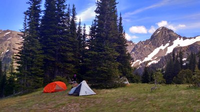
A hike through meadows, rocky alpine trails to camp on an alpine lake at the Goat Rocks Wilderness. Hopefully we'll even get to see marmots! Preference will be given to Luis&Karla's mentor group until May 30th, then open to all students with leader's permission.
- Sat, Aug 13, 2022 — Sun, Aug 14, 2022
- Foothills Backpacking Committee
- Backpacking
- Adults
- Moderate/Strenuous
- Moderate
- Mileage: 14.0 mi
- Elevation Gain: 4,100 ft
- High Point Elevation: 7,400 ft
- Pace: 2 mph
- 3 (5 capacity)
- FULL (2 capacity)
- Mon, Apr 4, 2022 at 8:00 AM
- Wed, Aug 10, 2022 at 12:00 PM
- Cancellation & Refund Policy
- iCal Google
Early meeting time to secure campsites at the lake.
Elevations listed are gains and losses along the hike. See net gain/loss on each day as well.
Day 1: 7.1 mi +2470ft, -780ft [Net gain of 1650ft]
Day 2: 6.7 mi +1718ft, -3390ft [Net loss of 1650ft]
Trees for hanging food can be about 0.2 – 0.3 miles away from camp. Bear canisters are an option to avoid walking that much to your food.
The following distances and elevations are given by GaiaGPS according to the planned route.
We will hike both under canopy and on rocky alpine trails.
On day one we will hike on the Snowgrass Trail, take the bypass to the PCT. We will try to find a good place for lunch on the PCT overlooking the Snowgrass Flats. After lunch, we will take back the Snowgrass Trail, shortly thereafter we will follow the Lilly Basin Trail. Finally, we will reach Goat Lake and set up camp. This makes for 9.15 miles and 3000ft of ascent.
On the second day we will continue hiking on the Lilly Basin Trail and take an out-and-back detour to the summit of Hawkeye Point. We will trace back so that we take the Goat Ridge Trail back to the trailhead. This makes for 6.7 miles with 1700ft of ascent. The way back has only one water source, which may be dry depending on the weather during the season. Be ready to carry all your water from camp.
- Average high: 78F
- Average Low: 42F
Most days in August are sunny, but this place has had rain and snow in August.
My trips tend to have a steady pace with few breaks apart from those for taking in the views or pictures.
Things that might cancel/reschedule the trip:
Thunderstorms, active fires nearby, unhealthy air quality, precipitation of over an inch per day or gale force winds in the forecast.
Berry Patch Trailhead (46.466664, -121.527575) at 7:30.
There is a first-come, first-served campground next to Chambers Lake
NW Forest Pass required.
Snowgrass Flat & Goat Lake Basin
-
Green Trails Goat Rocks William O Douglas Wilderness No. 303S
Green Trails White Pass No. 303
Green Trails Packwood No. 302
USGS Hamilton Buttes
USGS Walupt Lake
USGS Packwood Lake
USGS Old Snowy Mountain - See full route/place details.
Required Equipment
The Ten Essentials, plus overnight gear as specified by the trip leader.
Consider a bear canister.

