Trip Report
Sea Kayak - Carr Inlet
Great trip exploring inlets to their end at high tide.
- Sun, Dec 29, 2024
- Sea Kayak - Carr Inlet
- Carr Inlet
- Sea Kayaking
- Successful
-

- Road suitable for all vehicles
The launch site: We put in at the west end of Rosedale St. NW (47.330451, -122.655816). This is not a great launch site, especially at higher tides, but it provides the best option for this trip. There is no bathroom at this put-in but if needed there's probably one at the nearby Rosedale Market. There was sufficient space to park along the road, but one needs to respect the parking signage.
We staged and loaded boats in the small treed flat area at the end of the road, just above the beach. There is a narrow, awkward path of sorts with several big steps down to the beach. We spread ourselves out and passed the boats along, one at a time. The tide was 11 ft (Horsehead Bay station for all tide info) at launch and there was just enough beach to set all five boats down, with one end on the shore and the other half (or more) floating. A lower tide would make this process easier, but high tides are needed to get up all the inlets we explored.
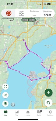
We launched at 9am. Wind was forecast for the afternoon so we paddled across Carr Inlet first thing, with an initial stop on the west side of Cutts Island. We paddled wide around the tip to avoid seals, then made a quick biobreak. The crossing to Glen Cove was smooth. With the high tide we paddled all the way to the end. The tidal LOW of 9.3 ft was near this point of the paddle, at 11:11am,
Next we paddled north along the shore to Minter Creek. We made a lunch stop on the sand spit at the cove entrance, just far enough around to be out of the wind but not in view from homes. After lunch the high tide allowed us to get all the way to the fish hatchery.
As expected, the wind had picked up by the time we were back to Carr Inlet and we observed little whitecaps. The group agreed to stay close, and we headed across to the north side of Allen Point for a biobreak, where I have a personal connection and can land. Otherwise groups should consider a biobreak at the mouth of Minter Creek just before crossing. It was a windy and wavy crossing. For some of the group this was the best part of the day. We estimate 15 knot wind with 20 knot gusts, and 2’ waves.
Next we followed the shoreline, around Allen Point and got a bit of respite from the wind. We passed our morning launch spot and two group members chose to end the trip there. The other three continued around to Lay Inlet. We paddled to the end and back, then further along the shore to the next cove. We paddled down the left branch to its end at the road, then back and down the right branch into a creek, past a couple ornate little fairy houses on the bank to where the steep mud banks in each side closed in and the bushes obscured any further passage. We backed out, and paddled back to the launch, returning at 3:15.
The tide was even higher when we returned, reaching its maximum High just then of 12.6 ft, and there was no exposed beach. We used a combination of tying boats off and having someone hold on to several, while one paddler at a time got out into the thigh-deep water, unloaded there floating boat, moved the gear up, then with help moved their boat up the “path” to the treed flat area.
Our group of 5 had an enjoyable trip with varied paddling!
Distance: 13.7 nm
 Lori Porter Stole