Trip Report
Basic Glacier Climb - Mount Logan/Banded Glacier
Long trail walk coming from Thunder Creek TH and steep/bush-whacking off-trail to base camp. Scrambling the worst loose rock col (Christmas col) and climb snow-covered Banded Glacier to the summit.
- Fri, Jun 28, 2024 — Sun, Jun 30, 2024
- Basic Glacier Climb - Mount Logan/Banded Glacier
- Mount Logan/Banded Glacier
- Climbing
- Successful
-

- Road suitable for all vehicles
-
- Trail condition: no difficulty to find the trail. Take Thunder Creek trail to Fisher Creek trail. Once reach location at 48.57238, -120.95362, we start the steep climb close to the ridge line. This is not a well-traveled area, so we did a lot of route finding. Avoid boulders and cliffs. Try to walk in between trees, since the areas will have less vegetation on the ground.
- Trying to walk around the lake at our base camp area is another challenge. There is a stream our group needs to walk across. We went upstream about quarter mile to find some logs to lay across the knee deep water. If there is no snow on the ground, it will be easier to camp on flat grounds before the stream crossing.
- Continue to scrambling uphill in the SSE direction. Going for another 2000 feet to reach top of the Christmas Col. Going down was easier than climbing up on the scree. Spread out and find solid boulders to walk on. Hugging the wall is probably a better option.
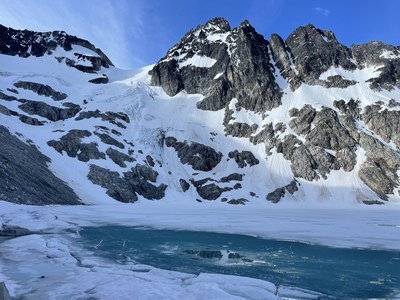
- Refill water at Banded Lake and then go up the glacier. Avoid any feature to the right of the glacier that funnels the avalanche snow. The most taken route is going to climber's left and stay high on glacier. In May-June condition, the group can decide to go up in a more direct route to save 1-2 hours of traveling.
- Transition from snow to summit ridge: 45-55 degree steep snow. Once on the ridge, walk around the false summit to reach the notch below the summit. A short downclimbing is need to reach the notch. Have a few cams for the summit block, since it was exposed and can cover in snow in some ledges.
- There are horns on the summit to sling for rappels. We did not find any slings, so we left one at the top this year. Follow the same way back to your base camp.
- Day 1: We Got to the ranger station at 6 am and was the first group at the door. Applied and received our permit within 10 mins. We got to the trail and start walking around 8:15 am. The elevation gain was gradual, but took us a long time and several breaks to get to the bottom of off trail scramble. Going up to our base camp was definitely not easy. Had to scramble very steep cliffs, wet boulder fields, go though very thick bushes and stiff tree branches. Finding flat areas to camp was challenging. There were not a not of ideal and dry flat ground across the stream. We had to settle for camping on snow, since it was the only flat area we could find. It rained when we were setting up tents, but stop when we went to bed at 10 pm.
- Day 2: Left camp at 430 am. Going up the rocky terrain and snow field for about 500 feet before we put on our crampons to start climb snow. Reach top of the Christmas col around 7 am. Everything is loose in the col, except the rock walls on both side. Dropped about 600 feet to reach Banded Lake. We refilled water here and figured out we could going up on a direct route than trying to traverse at the top of the glacier. Turned out there were no open crevasses, but one person did stepped into a crevasse over a snow bridge. Transitioning from the snow to the ridge-line was tricky. Snow was soft, but not firm enough to not post hole. Still, we managed get off the snow without trigger any slides. Scrambling to the summit notch short. Only one down climbing move that is class 4/5. We set up belays for students to summit Logan. We ran into white out condition when going down on the glacier, but we did follow our tracks back to Banded Lake. Going up Christmas col was a torture. We were able to reach our camp and going to sleep before the storm came in at night.
- Day 3: We were able to reinforced the makeshift bridge of the stream cross and safety cross the stream without falling in. We decides to walk underneath taller trees, so that we don't have to whack more more bushes. Found a trail on the ridge to walk back to Fisher Creek trail at around 10 am. Walked about another 6-7 hours back to the trailhead. Went to Upriver at Marblemount for our post climb meal. Another Everett's classic eight in the bag!
 Jason Hsu