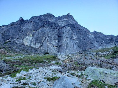
Sloan Peak/Fire on the Mountain
A seven pitch 5.10d alpine rock climbing route ascending the southwest face of Sloan Peak. The route follows a series of cracks, featured faces, and scrambling to the summit.
GETTING THERE
Drive the Mountain Loop Highway to 18.25 miles south of Darrington (~1 mile south of the Bedal Campground) or 7 miles north of Barlow Pass, and turn left onto Forest Road 4096. Drive 2 miles to the Bedal Creek Trailhead (2,800 ft).
Approach
Hike the Bedal Creek Trail (No. 705) for 2.5 miles along Bedal Creek, first through old-growth forest and then along Bedal Creek's steep banks. When the trail enters meadows beneath the west face, traverse up and right, crossing over the grassy shoulder that divides the west and southwest faces. Look for the chimney with lighter rock on the left, and darker to the right and the fairly obvious line on the southwest face, near the far right side of the wall.
ASCENT ROUTE
Climb the route as it follows a series of cracks, featured faces, and scrambling to the summit. There are seven pitches of rock climbing up to 5.10d to a major ledge intersecting the Corkscrew route, with about 500 feet of 4th-low 5th scrambling to the true summit along the Corkscrew route.
DESCENT ROUTE
Descend the entire corkscrew route or the descent for Sloan Peak/Southeast Face.
Notes
- Guidebook: Cascades Rock by Blake Herrington (2015).
- Suitable Activities: Climbing
- Climbing Category: Intermediate Alpine
- Seasons: July, August, September
- Weather: View weather forecast
- Difficulty: Intermediate Rock Climb
- Length: 12.0 mi
- Elevation Gain: 5,900 ft
- 7,835 ft
-
Land Manager:
Mount Baker-Snoqualmie National Forest
Henry M Jackson Wilderness, Skykomish Ranger District (MBSNF)
- Parking Permit Required: Northwest Forest Pass
- Recommended Party Size: 12
- Maximum Party Size: 12
- Maximum Route/Place Capacity: 12
- Green Trails Mountain Loop Highway No. 111SX
- USGS Sloan Peak
There are no resources for this route/place. Log in and send us updates, images, or resources.
