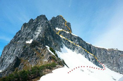
Sloan Peak/Southeast Face
Sloan Peak's Southeast Face is a Grade II, 5.7 alpine rock climb.
getting there
Drive the Mountain Loop Highway to Barlow Pass. Turn onto Forest Service road 4096 (marked by a very small sign). Follow this road to its end (~3.5 miles) and the Bedal Creek Trailhead (2,800 ft).
APPROACH
Hike up an old mining trail through dense forest and streams with many downfall trees until you reach Bedal
Creek. The trail follows the creek. A few cairns mark the way and eventually you must cross the creek to regain a well worn trail that leads to Bedal Basin passing a huge boulder. Follow the trail through thin forest and boulders until you see the West Face of Sloan Peak with a distant ridge coming off it. Travel cross country aiming for this ridge. The terrain up this ridge gets steep and is covered in vegetation and can be slick in the morning. Once on top of the ridge follow a worn trail through the trees that exits on a large scree field below the South West face. The ridge for the South East face should be visible in the distance. Contour and gradually gain elevation but don't go as high as the South West wall until you reach the top of the ridge. The South East face should now be visible. There is a good bivy site at this ridge and the views are spectacular.
Traverse the basin along the South East face. Dropping below rock bands reduces exposure to rockfall. In warmer weather water from snowmelt can be found running along these smooth granite surfaces. Continue to contour the
basin almost until you reach the rock wall that marks the ridge with the North East face. There will be a ramp on the South East face that runs up into a series of vegetation covered ledges.
Access to this ramp can be problematic and access to the ledges an even greater problem depending on snow conditions. Late in the season a large moat will form between the snow and the rock of the South West face that can block access to the ramp. It might be possible to drop into the moat and access the ramp. Given the right conditions one might be able to climb up what remains of the snow that covered the ramp, a snow tongue that no doubt melts out later in the season. Whatever method you use make sure you have a plan for how to get back onto the snow since the descent requires to
transition from the rocky ledges back to the snow.
The ramp itself is generally sound granite and easy 3rd class. Scramble along the ramp over boulders, rocks and vegetation covered slopes. No doubt you'll see evidence of rappel anchors used by others to exit the ramp system, most of questionable quality. Continue to follow the ramp up the face, staying close to the wall until you encounter the base of a gulley with a low 5th class friction step-up required for access. The move isn't exposed but thin. Ascend the gulley which is very loose and steep. It tops out at a trail which is the popuar "corkscrew route". Turning left heads uphill towards the summit. Heading right heads towards the base of the climb. Remember this spot as you will return here when it's time to
descend.
Turn right (downhill) and follow the corkscrew route. Soon you see a broken section of 5th class rock with a roof. This is the base of the climb. The route can be climbed in four pitches with a 60m rope.
ASCENT
Pitch 1 (5.7, 200 feet): Rope up to the left of the roof. Climb blocky Class 5 up and generally to the right until you reach a ledge just under one,
Pitch 2 (5.4-5.4, 200 feet): Climb straight up easy 5th class until reach a sand bench at roughly 100 feet out. Belaying from here will greatly reduce rope drag.
Pitch 3 (5.4-5.5, 200 feet): From the belay on the sandy ledge walk left until you see an granite wall with a few chicken heads and ridges. Super fun slab to climb, although way too short. This leads to a rough chimney system, more like an extended open book. Very easy climbing to another large open ledge on the arm that leads to the summit.
Pitch 4 (low Class 5 to Class 4): Climb up the arm until you reach scramble terrain, perhaps 200 feet from the belay. The climbing is super easy, perhaps bordering on Class 4. From here it's an easy scramble up blocks to the ridge leading to the summit.
DESCENT
The descent follows the famous corkscrew route off the summit. Follow trail and cairns until you reach the top of the gully that granted access from the South East face ledge system to the corkscrew route. Carefully descend the gully as it's very loose. Downclimb the low 5th class step or rig a hand line or rappel. It's not steep or exposed. Reverse the route down the ramp to the snow, then return via the approach route.
- Suitable Activities: Climbing
- Climbing Category: Intermediate Alpine
- Seasons: July, August, September
- Weather: View weather forecast
- Difficulty: Intermediate Rock Climb
- 7,835 ft
-
Land Manager:
Mount Baker-Snoqualmie National Forest
Henry M Jackson Wilderness
- Parking Permit Required: Northwest Forest Pass
- Recommended Party Size: 12
- Maximum Party Size: 12
- Maximum Route/Place Capacity: 12
- USGS Sloan Peak
There are no resources for this route/place. Log in and send us updates, images, or resources.
