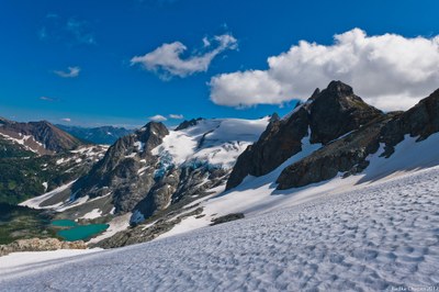
Ptarmigan Traverse
The classic and rugged 35+ mile, high alpine traverse from Cascade Pass to the Suiattle River.
Suggested Itinerary
Peaks that may be climbed along the way include Mix-up Peak, Magic Mountain, "Hurry-up" (S Mountain), Mount Formidable, Spider Mountain, Le Conte Mountain, Sentinel Peak, Old Guard, The Lizard, German Helmet, Spire Point, Gunsight Peak, Dome Peak and Sinister Peak.
Most parties do the Ptarmigan Traverse in 5-7 days but you may do it in fewer or more days depending on your party's fitness and desires. Here's a sample seven day itinerary:
- Day 1 - Cascade Pass to Kool Aid Lakes
- Day 2 - Kool Aid Lakes to Yang Yang Lakes
- Day 3 -Yang Yang Lakes to White Rock Lakes
- Day 4 -White Rock Lakes to Itswoot Ridge or Cub Lake
- Day 5 - Dome Peak
- Day 6 - Itswoot Ridge or Cub Lake to Downy Creek or continue to cars
- Day 7 - Downey Creek to cars via Suiattle River Road
- Suitable Activities: Climbing
- Climbing Category: Intermediate Alpine
- Seasons: June, July, August, September
- Weather: View weather forecast
- Difficulty: Intermediate Mountaineering Climb
- Length: 35.0 mi
- 8,920 ft
-
Land Manager:
North Cascades National Park
Glacier Peak Wilderness, Entiat Ranger District (OWNF)
- Parking Permit Required: Northwest Forest Pass
- Recommended Party Size: 12
- Maximum Party Size: 12
- Maximum Route/Place Capacity: 12
- USGS Dome Peak
- USGS Downey Mtn
- USGS Cascade Pass
- Green Trails North Cascades Ross Lake No. 16SX
- Trails Illustrated North Cascades National Park
| Name/Description |
|---|
| Mountaineers Beta & Brews: Ptarmigan Traverse The Mountaineers Beta & Brews "Ptarmigan Traverse" presented on Jun 2, 2021 by Catharine Killien. |
| Mountaineers Beta & Brews: Ptarmigan Traverse and the Tooth Fairy with Jim Nelson The Mountaineers Beta & Brews "Ptarmigan Traverse and Tooth Fairy" presented on Nov 27, 2021 by Jim Nelson. |
