
Dome Peak/Dome Glacier
A strenuous but rewarding climb to a high, massive and remote peak. While there are multiple approach options to Dome Peak, none of the approaches are easy. The rock ridge is exposed, so some parties have taken rock gear to belay and/or set up fixed rope(s). Times: 9-11 hr to camp, 6-8 hr camp to summit.
getting there
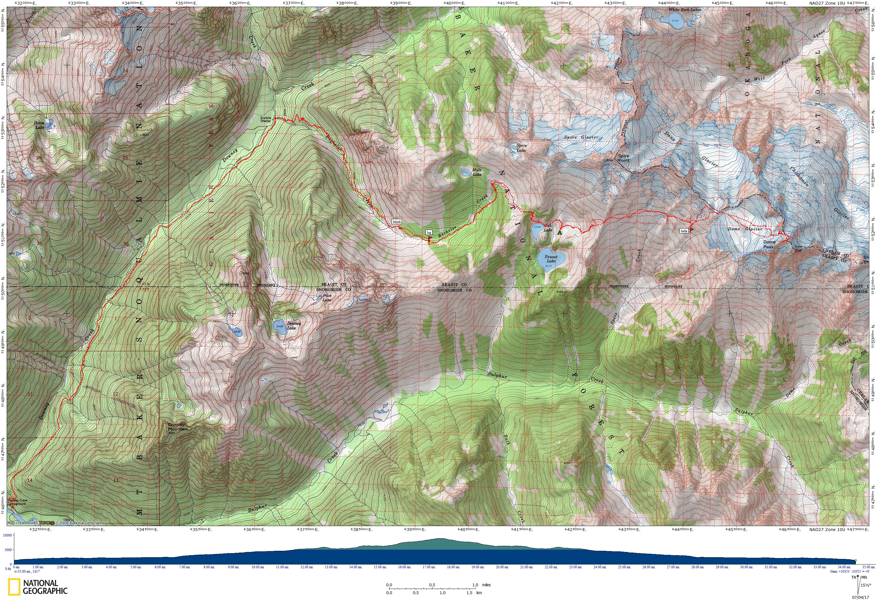
Take I-5 to Arlington, then SR-530 to Darrington. Driving north from Darrington, turn right on the Suiattle River Road (Forest Road 26). Go 19.5 mi to Downey Creek Campground and the trailhead (1,450 ft).
APPROACH
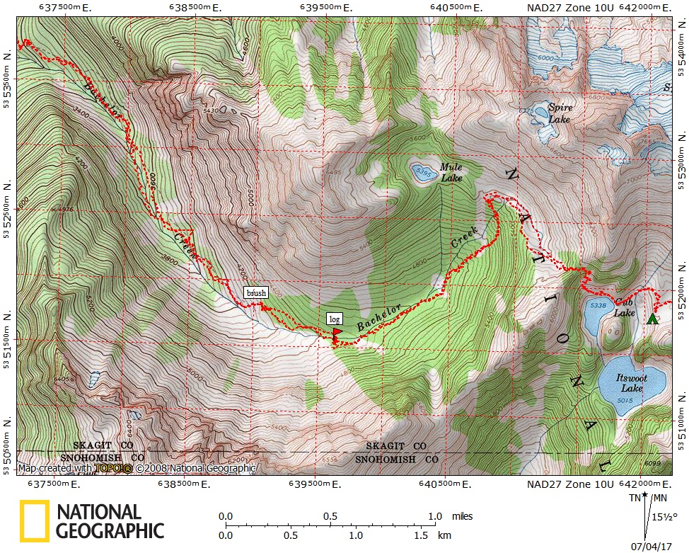
Take the Downey Creek Trail to Bachelor Creek (6.5 mi) staying on the east bank of Downey Creek. Just past the second crossing of Bachelor Creek at 4000 ft is an over grown trail that traverses a slide alder patch. The correct trail is the one closest to Bachelor Creek. Follow trail past Cub Lake to camp in meadows southeast of lake, or proceed up to camp on ridge another hour, elevation 6,200 ft.
ASCENT ROUTE
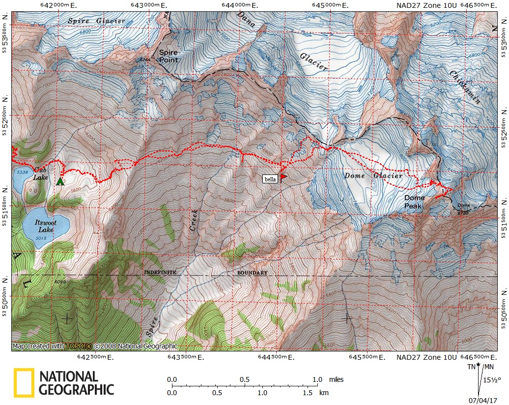
dome glacier
Basic Glacier Climb
From base camp, follow a foot path to cross the south ridge leading toward Spire Point at 6,200 ft. Drop down approx 200 ft and traverse at a bearing of 80° to below a prominent cliff. Continue on a 57-60° bearing to a shallow depression (glacier-polished rock in late season) on a heathered ridge. Then go dead east to below the lower cliff of another spur ridge. From here ascend a broad snow slope (boulder field in late season) at an 80° bearing to just below the top of the ridge. Traverse onto the Dome Glacier and follow a 115° bearing. On the upper glacier, climb through crevasses to the notch at 8,560 ft, just north of the summit. On the other side of the notch climb along the snow slope for 300 ft to top, and then climb a rock arête for 500 ft to the summit (8,920 ft). Descend the climbing route.
dome traverse
Intermediate Mountaineering Climb
Traverse east from Itswoot Ridge across snow and talus to Dome Glacier. Ascend glacier to a flat section at 8,000 ft (see Selected Climbs in the Cascades, p. 118, for a variation involving more rock but a bit of doubling-back.) Ascend east on snow slopes to a gully leading to the col between Dome and Chickamin Glaciers (8,450 ft). Climb up to the col, then follow snow ridge southeast to benches and the final 50-foot section of rock scrambling to the southwest summit of Dome Peak. Traverse east on the summit ridge (sharp and exposed, but terrific rock), staying mainly on the south side of the ridge crest, to the northeast (main) summit of Dome Peak. The traverse is mainly low Class 5 but finishes with a 5.5 crack. Descend the Dome Glacier route (above).
TRIP PROFILE
| SEGMENT | TIME (HOURS) | ELEVATION GAIN (FEET) | ELEVATION LOSS (FEET) |
|---|---|---|---|
| Trailhead to Camp | 9-11 | 4,550 | 700 |
| Camp to Summit | 6-8 | 3,582 | |
| Summit to Camp | 4-6 | 3,582 | |
| Camp to Trailhead | 6-8 | 700 | 4,550 |
EQUIPMENT
Standard glacier equipment.
NOTES
This is a long and strenuous climb to a major and remote wilderness peak. It should be scheduled for three full days.
- Suitable Activities: Climbing
- Climbing Category: Basic Alpine
- Seasons: July, August, September
- Weather: View weather forecast
- Difficulty: Basic Glacier Climb, Strenuous 5, Technical 2, Basic Experience Climb
- Elevation Gain: 8,132 ft
- 8,920 ft
-
Land Manager:
Okanogan-Wenatchee National Forests
Glacier Peak Wilderness
- Parking Permit Required: Northwest Forest Pass
- Recommended Party Size: 12
- Maximum Party Size: 12
- Maximum Route/Place Capacity: 12
- USGS Dome Peak
- USGS Downey Mtn
- USGS Cascade Pass
- Green Trails Mountain Loop Highway No. 111SX
This is a list of titles that represent the variations of trips you can take at this route/place. This includes side trips, extensions and peak combinations. Not seeing a title that fits your trip? Log in and send us updates, images, or resources.
- Dome Peak/Dome Traverse