Trip
Day Hike - Beverly Creek Basin & Volcanic Neck
Moderate fall hike in the Teanaway Region east of the Cascade Crest
- Wed, Oct 12, 2022
- Seattle Hiking Committee
- Day Hiking
- Adults
- Moderate
- Moderate
- Mileage: 6.2 mi
- Elevation Gain: 1,900 ft
- High Point Elevation: 5,560 ft
- Pace: 2.0
- FULL, 1 on waitlist (11 capacity)
- Thu, Sep 15, 2022 at 10:19 AM
- Mon, Oct 10, 2022 at 5:00 PM
- Cancellation & Refund Policy
- iCal Google
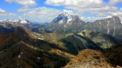
We will hike first through the forest and then along ridge tops with open meadows and glorious views, rumored to have ripe huckel berries.
The turnaround point is the pass between Beverly Creek basin and Fourth Creek Basin at 3.5 miles from the trailhead . Elev 5560.
Meet at the Beverly Creek Trailhead at the end of FS road 9737-112 at 9 am and hit the trail at 9:20. This hike is listed as number 110 in the book "Day Hiking in the Snoqualmie Region by Dan A. Nelson.
Directions: Drive east on I90 to exit 85. Cross over the freeway and turn right on State Route 970. Cross the Teanaway River Bridge and in another mile turn left on Teanaway River Road veering right as it becomes first North Fork Teanaway road then unpaved Forest road 9737 at 29 Pines Campground. Continue north for just under 4 miles before turning right on rd 9737-112, Beverly Creek. The trailhead is in 1.4 miles.
Bean Creek Basin
-
Green Trails Alpine Lakes East (Stuart Range) No. 208SX
Green Trails Mt Stuart No. 209
USGS Teanaway Butte
USGS Mount Stuart
USGS Red Top Mtn
USGS Enchantment Lakes - See full route/place details.
Required Equipment
- Navigation
- Headlamp
- Sun protection
- First aid
- Knife
- Fire
- Shelter
- Extra food
- Extra water
- Extra clothes
