Trip Report
Day Hike - Lower Big Quilcene
Recent trip reports from work parties indicated a clear trail through about 3.5 miles. After that we were on our own to see how far we could make it prior to being stopped due to fallen trees. We actually made it to within about a half mile of Camp Jolly before turning around.
- Mon, Feb 14, 2022
- Day Hike - Lower Big Quilcene
- Lower Big Quilcene
- Day Hiking
- Successful
-

- Road suitable for all vehicles
-
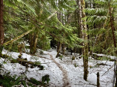
The trail is clear for the first 4 miles or so. It is obvious that work crews have been on the trail clearing fallen trees. After the first 4 miles following the trail involves a little bit of climbing over multiple logs due to fallen trees. We came to three places where we discussed turning around due to trail conditions but safely navigated them. At about 4.5 miles we came to an area that we couldn't get through and going around meant post-holing in deeper snow, something we weren't comfortable doing due to the possibility of injury, so we turned around.
Seven of us met at the Quilcene Ranger Station at 8:45 a.m. and caravanned to the trailhead; there were no other cars, and we were on the trail by 9:30. We went up and over a section/bypass that has been built since the last time I hiked this trail that is just passed the Notch Pass intersection. The river was beautiful today and I enjoyed hearing it near us for most of the day. In spite of a light rain most of the time, it was a pleasant hike and we enjoyed the intensity of the greens on this wet day. There is still some snow on the trail starting after Bark Shanty Camp, and about half of our group wore micro spikes for the return part of the trip when we were going downhill more frequently. We saw one other hiker all day. 
 Becky Andrade