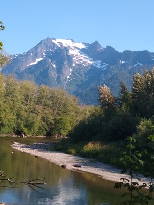
Whitehorse Mountain/Northwest Shoulder
A strenuous early season climb with 7,000 feet of elevation gain, lots of blowdowns, a glacier crossing, possibly a moat, and a short, exposed rock scramble at the end. Enjoy great views in all directions from the summit and lots of solitude. This is a long climb, requiring an early start. It's 12-14 hours from the trailhead to the summit.
Getting There
Drive north on I-5 through Everett. About 11 mi north of Everett turn right (east) onto SR-530 to Arlington. Continue on SR-530 about 23 mi east of Arlington (5 mi west of Darrington) to Shell Station at Mine Road/387 Ave. Turn right (south) and in 0.5 miles park at the closed bridges over Moose Creek. Walk the road, turning left at each of the next two forks. Shortly after crossing Furland Creek, the trailhead is marked “Niederprum Camp” (on the right, about 2 mi from the store).
APPROACH
Hike up the Niederprum Trail about 2 miles to 3,000 ft. Leave trail here and make gently rising traverse to the left (south) through forest for about 0.5 mile to a wide couloir which should be snow filled until early July. In late season, it is best to take the trail to its end, then traverse below cliffs and above brush to near head of the couloir.
AAscend the couloir to Lone Tree Pass at 5,000 ft, then turn left and traverse east and down about 500 feet to near a small lake. Make a long rising traverse east eventually reaching a broad open slope. Ascend slope/gully to High Pass at 6,100 ft. Cross the pass to Whitehorse Glacier.
ASCENT ROUTE
Ascend the glacier to the snow ridge, then up the ridge to the moat near the summit rrock. The moat is crossable in early sseason. Snow aanchorsmay be needed to belay the crossing to the rock. The final bit of rock is a short scramble that is somewhat exposed. Rope leaders may want two to four stoppers.
DESCENT ROUTE
Descend the climbing route.
TRIP PROFILE
| SEGMENT | TIME (HR) | ELEVATION GAIN (FT) |
|---|---|---|
| Trailhead to High Pass | 7-8 | 6,100 |
| High Pass to Summit | 2-3 | 800 |
| Summit to Trailhead | 6-7 |
EQUIPMENT
Standard alpine equipment and crampons. Some parties bring glacier gear but trip reports indicate that it is not always used.
NOTES
Car camp is recommended as this is a very long climb and requires an early start in the morning. The other climbing route via the Whitehorse Glacier should be avoided as it is dangerous (avalanches, rockfall). This climb is an excellent conditioner in early season. Consider stopping at the Texaco station (where Whitehorse Merchantile used to be) and looking at route before climb (Lone Tree Pass is not obvious from directly below).
Bridge over Moose Creek closed and barricaded for safety reasons in 2008. You can car camp at the closed bridge.
- Suitable Activities: Climbing
- Climbing Category: Basic Alpine
- Seasons: April, May, June
- Weather: View weather forecast
- Difficulty: Basic Alpine Climb, Strenuous 3, Technical 2, Basic Experience Climb
- Length: 12.0 mi
- Elevation Gain: 7,000 ft
- 6,840 ft
-
Land Manager:
Mount Baker-Snoqualmie National Forest
Boulder River Wilderness, Darrington Ranger District (MBSNF)
- Parking Permit Required: Northwest Forest Pass
- Recommended Party Size: 12
- Maximum Party Size: 12
- Maximum Route/Place Capacity: 12
- USGS Whitehorse Mountain
- Green Trails Silverton No. 110
There are no resources for this route/place. Log in and send us updates, images, or resources.
