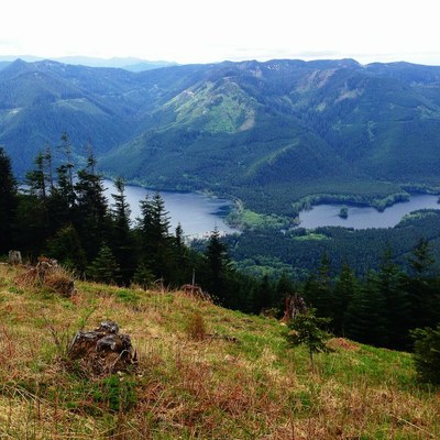
Mount Washington (Snoqualmie)
A strenuous, eight mile hike with 3,200 ft in elevation gain. Starting in second growth forest, hike up to a road turned trail through an open area to a ridge summit with views of Chester Morse reservoir, Mount Rainier and the peaks on the north side of Snoqualmie Valley. Consider adding Change Peak, Greenway Mountain, Machu Picchu, and/or Songbird Peak (aka MMM Peak) & Easter Island, lesser known peaks near Mount Washington, to your trip. Hike or scramble to just one, any two or all three of them.
getting there
Take Exit 38 off of eastbound I-90, turn right, cross the river, turn right again, and park at the Twin Falls/Olallie State Park parking lot and trailhead (1,220 ft). There are bathrooms at trailhead.
on the trail
Mount Washington (4,405 ft)
8 miles round trip, 3,200 feet of elevation gain
Hike south and then west up the short connector trail to the Palouse to Cascades State Park Trail (formerly Iron Horse/John Wayne Trail), then merge onto a wide gravel road, staying right. The road intersects another road, the Palouse to Cascades State Park Trail. Continue west (right) and then turn left (south) onto the next unmarked trail, ~0.3 miles from the trailhead. It's marked by a small rock cairn if it's not buried in the snow (skip the light sensor access trail, it's just past that). The trail climbs steeply to the southwest, then eases to a moderate grade with crossings of several small creeks. It switchbacks through old growth forest with occasional views to the north. Less than a mile from the trailhead, the trail passes under a small cave now used as a climbing wall, with several anchors on the overhang and sometimes people hanging from them!
The trail then veers right at a hand-carved wooden sign that reads “MT WA.” At ~1.6 miles from the trailhead, a small clearing noted on small maps as “Owl Hike Spot” provides views of Rattlesnake Ledge to the west. Continue climbing and stay right at the junction with the Great Wall Trail at 2.0 miles and the first views of the summit. The grade moderates, leaves the forest, and turns sharply east toward another unmarked trail junction. Bear right (west) to stay on the main path, climbing in long switchbacks. The route finally breaks out into alpine meadow at about the three mile mark. Flowers are here in the early summer. At a sharp switchback is the boundary between public land and the Cedar River Watershed, the water supply for the city of Seattle. Hike around the southwest-facing slope and climb north on a gentle ridge to the summit.
Change Peak (4,340 ft)
8 miles, 3,000 feet of elevation gain
From the Great Wall Trail, ascend the southwest ridge.
Greenway Mountain (4,460 ft)
Follow logging roads on the ridge from Change Peak until it's possible to scramble to the summit of Greenway Mountain.
information FOr leaders
Permit information
As of 2017, the Snoqualmie Ranger District considers Mountaineers trips and courses to be "nominal use". Leaders should print and copy this designation letter to show rangers they may see on trail.
- Suitable Activities: Day Hiking, Scrambling
- Seasons: June, July, August, September, October, November
- Weather: View weather forecast
- Difficulty: *Varies*, Strenuous, Winter Scramble
- Length: 8.0 mi
- Elevation Gain: 3,200 ft
- 4,405 ft
-
Land Manager:
Mount Baker-Snoqualmie National Forest
Snoqualmie Ranger District (MBSNF)
- Parking Permit Required: Discover Pass
- Recommended Party Size: 12
- Maximum Party Size: 12
- Maximum Route/Place Capacity: 12
- Green Trails Mount Si NRCA No. 206S
- Green Trails Bandera No. 206
- USGS Chester Morse Lake
This is a list of titles that represent the variations of trips you can take at this route/place. This includes side trips, extensions and peak combinations. Not seeing a title that fits your trip? Log in and send us updates, images, or resources.
- Change Peak
- Greenway Mountain
- Machu Picchu
- Songbird Peak & Easter Island
- Mount Washington Area Peaks
- Mount Washington & Change Peak
- Change Peak & Greenway Mountain
- Mount Washington & Greenway Mountain
- Mount Washington, Change Peak & Greenway Mountain
- Greenway Mountain, Machu Picchu, Songbird Peak & Easter Island
- Greenway Mountain, Songbird Peak & Easter Island
There are no resources for this route/place. Log in and send us updates, images, or resources.
