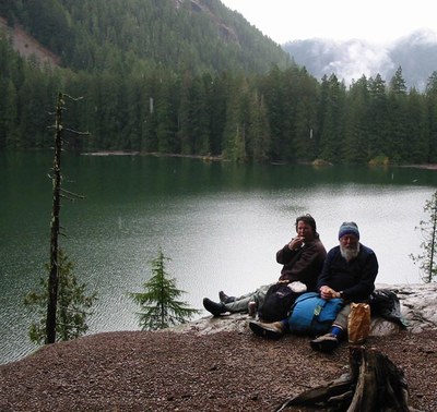
Lena Lake
A moderate, 6-mile round trip day hike with 1,300 ft of elevation gain to the lower lake. The upper lake is more challenging and strenuous at 14 miles round trip with 4,100 feet of elevation gain. The trail goes up through forests above Lena Creek to a secluded lake. This is a beautiful sub-alpine lake formed by a massive rock slide 5,000 years ago. Continue on as far as Upper Lena for a longer, more challenging outing.
GETTING THERE
From the eastside of Puget Sound: Take the Seattle-Bainbridge Ferry to Bainbridge Island. Continue straight off the Ferry Dock onto WA-305 N/Olympic Dr SE. In Poulsbo, take a right onto WA-3 N towards the Olympic Peninsula. Take a left onto the Hood Canal Bridge and follow WA-104 W. Take a left on Center Rd. When you get into Quilcene, take a left onto US-101 S. After 29 miles, take a right on Hamma Hamma Rd. About 8 miles down the road you will see the Lena Lakes/The Brothers trailhead on the right (700 ft).
South of Seattle: Take US 101 north to Hamma Hamma Rd (about 50 miles from Olympia). Take a left on Hamma Hamma Rd and drive ~8 miles until you reach the Lena Lakes/The Brothers trailhead (700 ft).
On the trail
Lower Lena Lake
6 miles round trip with 1,225 feet of elevation gain, 1,925 ft high point
Hike the Lena Lake Trail No. 810 starting with a quick 700-foot ascent on 17 switchbacks. You'll be surrounded by second and old growth moss covered trees that bathe you with a delightful green color. Remnants of logging days past are also visible along the trail. A bit less than half way to Lena Lake, a bridge crossing passes over dry rocks, but the creek sinks below the surface before and after the bridge most of the year. After a brief ascent past the bridge, a moss covered rock overlook presents views of the Lena Creek basin. Reach Lena Lake 3.0 miles from the trailhead. Take the right fork to continue to camping and a slightly longer path to Upper Lenba Lake that hugs Lena Lake, or take the left for to hike to Upper Lena Lake.
Upper Lena Lake
14 miles round trip with 4,100 feet of elevation gain, 4,600 ft high point
Hike 3.5 miles from Lena Lake to Upper Lean Lake. Start by crossing an unnamed creek and then begin ascending in earnest through the forest to the alpine level. On your journey up trees gradually thin until they disappear. Cross Lena Creek ~0.5 mile before reaching Upper Lena Lake. At the end of you journey uphill you'll be rewarded with great views of Mount Bretherton and Mount Lena, both little cousins to the big fellow in the neighborhood, The Brothers.
- Suitable Activities: Day Hiking
- Seasons: April, May, June, July, August, September, October, November
- Weather: View weather forecast
- Difficulty: Easy/Moderate
- Length: 6.0 mi
- Elevation Gain: 1,300 ft
- 2,000 ft
-
Land Manager:
Olympic National Forest
The Brothers Wilderness, Hood Canal Ranger District (ONF)
- Parking Permit Required: Northwest Forest Pass
- Recommended Party Size: 12
- Maximum Party Size: 12
- Maximum Route/Place Capacity: 12
- Green Trails The Brothers No. 168
- Green Trails Olympic Mountains East No. 168S
- Custom Correct Mount Skokomish - Lake Cushman
- Custom Correct Brothers - Mt Anderson
This is a list of titles that represent the variations of trips you can take at this route/place. This includes side trips, extensions and peak combinations. Not seeing a title that fits your trip? Log in and send us updates, images, or resources.
- Lena Lakes
- Lower Lena Lake
- Upper Lena Lake
- Lower & Upper Lena Lakes
There are no resources for this route/place. Log in and send us updates, images, or resources.
