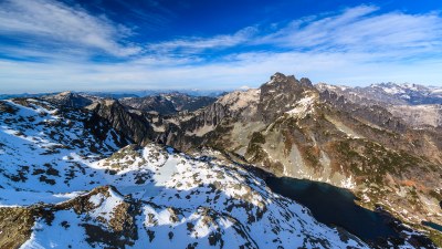
Chikamin Peak
A challenging scramble covering 24 miles and 5,400 feet of elevation gain in the Alpine Lakes Wilderness. It is often visible from I-90 looking up the Gold Creek Valley. With its length and plentiful camping along the Pacific Crest Trail, it's best done as a 2-3 day trip. Enjoy bountiful views over the Snoqualmie "Alps," amazing lake camping, and a Class 3 scramble finish.
Getting there
From I-90, exit in Cle Elum for SR-903. Follow it past Cle Elum and shortly after the lake turn left onto Forest Road 46. Continue during Forest Road 46 to the trailhead is at the end of the road (2,375 ft).
Approach & ascent
From Mineral Creek Trailhead hike to Park Lakes. The trail then goes on the ridge between the two lakes and meets the Pacific Crest Trail (PCT). Take PCT in direction of Snoqualmie Pass, traveling the PCT for a short distance and leaving it just after a pack camp at 5,200 ft.
Head for the saddle between Peak 5402 and Peak 6300. There is a boot path visible just where the Pacific Crest Trail begins to head west. From saddle continue to follow boot path and head toward east side of Glacier Lake and around it until reaching a large talus field (a gully with a drainage). There is a large rock sitting vertically on its side several hundred feet above the talus field, but it may not be seen from the lake. This rock identifies the gully and drainage on the north side of Glacier Lake that leads to the small unnamed lake above and northwest of Glacier Lake. The drainage may be dry or a trickle in late summer.
There is a boot path that is lost among the large rocks but picked up periodically on heather. From the small, unnamed lake above Glacier Lake, travel along the south side of the lake then head generally west to southwest up large rock and heather faces to saddle south of Chikamin Peak at ~6,200 ft (alternatively the ridge north of the saddle at ~6,400 ft can be easily gained). From the saddle head north to the summit. There is a faint boot path.
Alternative Route
At Park Lakes, from the upper lake, ascend the saddle to its southwest and then turn up the mixed heather and slab slopes to attain Chikamin Ridge, a bit northwest of its saddle with Four Brothers—this is an excellent opportunity to practice slab technique. Ascend the ridge to where it broadens out to a gully and then the heather dappled slopes on the gully’s right. At the summit block angle up and left on slabs and benches, aiming for a noticeable slot angling back right. The slot contains about a 10 feet of a well-protected vertical chimney. Another 75 feet of easy scrambling leads to the summit.
- Suitable Activities: Scrambling
- Seasons: June, July, August, September, October
- Weather: View weather forecast
- Difficulty: Strenuous 5, Technical 4
- Length: 24.0 mi
- Elevation Gain: 5,400 ft
- 7,000 ft
-
Land Manager:
Okanogan-Wenatchee National Forests
Alpine Lakes Wilderness
- Parking Permit Required: Northwest Forest Pass
- Recommended Party Size: 12
- Maximum Party Size: 12
- Maximum Route/Place Capacity: 12
- USGS Polallie Ridge
- USGS Chikamin Peak
- Green Trails Kachess Lake No. 208
- Green Trails Snoqualmie Pass No. 207
There are no resources for this route/place. Log in and send us updates, images, or resources.
