Trip
Day Hike - Kendall Katwalk
A strenuous 11 ml. round trip hike with 2,700 ft. elevation gain along the Pacific Crest Trail starting at Snoqualmie Pass with amazing views on a fine day.
- Fri, Jul 28, 2017
- Foothills Hiking Committee
- Day Hiking
- Adults
- Strenuous
- Challenging
- Mileage: 12.0 mi
- Elevation Gain: 2,600 ft
- FULL, 1 on waitlist (11 capacity)
- Wed, Jul 12, 2017 at 6:00 AM
- Wed, Jul 26, 2017 at 4:00 PM
- Cancellation & Refund Policy
- iCal Google
Please note: If there is remaining snow on the higher elevations of the trail such that it is unwise or unsafe to travel to or along the Katwalk, I will offer an alternative hike to Island and Rainbow Lakes from the Olalie Lake Trailhead, Exit 45 off I-90. It's 10 miles round trip, 2,400 ft. gain. There the highest point is 1,000 ft. lower than at the Katwalk, and all the trail therefore will for certain be snow-free. (Same map applies). I will make the determination after studying trips reports the weekend before and let everyone registered know.
PLEASE DON'T REGISTER UNTIL YOU HAVE REVIEWED THE NOTES BELOW, YOU ARE SURE YOU ARE AVAILABLE AND THE MEETING TIME AND LOCATION WORK FOR YOU.
If you are hoping for a ride you will have a better chance if you set your profile to "Open" and provide carpool information such as the area you live in and locations you can reach by transit to meet a driver.
BY REGISTERING THIS LEADER CONSIDERS YOU MADE A COMMITMENT TO THE TRIP. It's only good form to cancel in the event of an injury, illness or an emergency. Even if there are people on the wait list it's often difficult to move them up close to the trip date. THANK YOU!
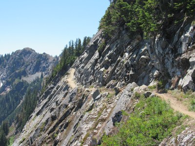
TRIP DESCRIPTION: Kendall Katwalk is a strenuous 11 ml. round trip with 2,700 ft in elevation gain. The hike takes us from the north Snoqualmie Pass PCT trailhead to a narrow trail blasted into the cliff face with views of wildflowers and mountain ridges. After lunch we will return by the same route. The hike follows the Pacific Crest Trail. In the view of the WTA description this is one of the most impressive walks on the Washington state portion of the PCT.
The map for our day trip is: GT Snoqualmie Pass Gateway #207S
We will travel at a moderate pass (av. 2 mph). A high level of fitness and stamina is required to register for this trip in view of the distance and elevation gain. It's important that all the group can keep together. So, if you feel this trip might be either too strenuous or alternatively not challenging enough please consider if it is right for you.
Full trip details including how to find the meeting place and carpool information provided by participants who have set their profiles to "Open" will be emailed as soon as registration closes at 4 pm on Aug. 9. PLEASE LOOK OUT FOR THIS EMAIL!
Please direct any questions to the trip leader: Chris Ensor ctrails@comcast.net
8:30 am North Bend Safeway close to the tall Safeway/O'Reilly Auto Parts/Chase Bank sign in the parking lot. It's close to I-90 exit 31.
Full trip details including how to find the meeting place and carpool information provided by participants who have set their profiles to "Open" will be emailed as soon as registration closes at 5 pm on Aug. 9. PLEASE LOOK OUT FOR THIS EMAIL!
Kendall Katwalk
-
Green Trails Snoqualmie Pass Gateway No. 207S
Green Trails Snoqualmie Pass No. 207
USGS Snoqualmie Pass - See full route/place details.
Required Equipment
- Navigation
- Sun protection
- Insulation (extra clothing)
- Illumination
- First aid supplies
- Fire
- Repair kit and tools, including knife
- Nutrition (extra food)
- Hydration (extra water)
- Emergency shelter
