Trip Report
Myrtle Lake (Entiat)
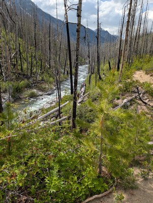
Easy out and back through a valley recovering from a 10 year-old wildfire. Come for wide open views and a chance to watch nature heal.
- Sun, May 25, 2025 — Mon, May 26, 2025
- Myrtle Lake (Entiat)
- Backpacking
- Successful
-

- Road rough but passable
-
- Trail conditions:
- Snow free throughout the route. As near as I could tell, the south facing slopes in the Entiat valley were completely clear of snow up to the crests of the ridge, while the north facing slopes were still harboring snow at fairly low elevations; the west side of Myrtle Lake had snow at lake level, but the east side access trail and south side campground were free of snow.
- Trail's a mix of dusty dirt and some gravel/rocks. Even with rain overnight, there was practically no mud unless right next to a water source. In some places the vegetation is sparse and you get wide open views of the valley and surrounding mountains. In other places the brush gets quite close in around the trail, limiting sightlines- keep in mind this might lead to closer wildlife encounters. I overtook a deer and we spotted each other only 20 yards away.
- Trail Obstacles:
- Entiat River trail is completely clear of blowdowns. Looks like some recent work has been done to clear several- thanks to all who are working hard to keep this trail clear!
- Myrtle Lake access trail has approximately 5 blowdowns along the east shore trail, all easily passable by going up and over. The last 20 yards or so of the trail into the campsite appeared to be flooded out and required some very minor bushwhacking.
- About 100 yards from the trailhead is an ankle deep stream crossing. I could make it over by jumping on a log on the right hand side, but only barely. If you've got a short stride or difficulty with balance, be prepared to get your feet wet. This was the only significant stream crossing without an obvious bridge or set of stepping stones.
- The Anthem Creek Bridge (2.5 miles in) is in good condition.
- Bridge across Entiat River leading towards Myrtle Lake is in good condition.
Hiked in to Myrtle Lake S Campsite via the Entiat River trail for a one night out and back. Please note that this report only covers the first 4ish miles of the Entiat River Trail. Go further in and YMMV. Highlights
- Road Conditions:
- Minor potholes. Did fine with a Subaru outback.
- One area of running water across the trail.
- Several areas where road went down to a single lane due to erosion or old blowdowns. It was always passable, but occasionally required some tight negotiation when passing other cars.
- Trailhead: Well maintained vault toilet. Plenty of parking.
- Route Finding Issues: None. Trail is well marked with intact signposts at every intersection.
- Weather conditions throughout your trip:
- Sunday evening- Sunny, clear skies, little wind. Guessing it was in the 80s. With the lack of shade due to all the trees being dead/down, it felt quite warm.
- Sunday night- Cool, occasional light rain. Guessing mid to high 50's.
- Monday morning- Overcast giving way to partly cloudy by about 7:30.
- Start and end times- Started 3pm Sunday, at camp by about 6pm. Broke camp by 6:50am and at the trailhead by 8:30am. Took occasional breaks both ways, but nothing more than 15 minutes.
- Water sources: Approximately 5 streams across the Entiat River Trail, and then access again at the Entiat River Crossing and along Myrtle Lake
- Potential campsites/natural shelters:
- There is very little shade or natural shelter along the Entiat River trail.
- There are established campsites at the N and S end of Myrtle lake.
- Any safety concerns:
- Lots of dead standing trees, and several leaning ones. The South side of Lake Myrtle had many hazardous trees which were either leaning, or collapsed and hung on another standing tree. I heard one tree blowdown in the early evening. There is one hanging directly above the toilet- I elected to hold off on using it for #2 and waited to get back to the trailhead instead.
- There are several signs which advise hikers r/e wildfire danger. Check out this article for generic post fire safety on trail. TLDR? Lots of standing dead trees = higher blowdown risk, especially in high winds. Less vegetation = higher flood and washout risk, so be wary along streams and drainages, especially during high rain periods.
- There were two deer (a doe and a yearling buck) which were wandering around the south campsite area. They appeared to be habituated to humans, and very interested in my dog. On several occasions when they saw me they began to walk closer; eventually when I banged a stick or a pot they would run 10 or 20 yards away. Guessing that the closest they got was 30 yards.
- Wildlife: Saw 3 deer, plenty of butterflies, a duck couple on the lake, and several chipmunks.
- Other Neat Things:
- The wildfire damage along this trail is really interesting, even 10 years out from the 2015 fire that caused it. You can very clearly see the boundary between burned and unburned land on the drive in. Because almost all of the old-growth trees are dead, you are greeted with wide views across the valley most of the time. Everywhere around the trail, densely packed pine saplings alternate with clusters of thick bushes (salal I think) that wouldn't be able to get any sunshine in the understory of an old-growth forest. This was a unique opportunity to watch nature heal.
Happy Trails!
 Connor Gudmundsson