Trip Report
CHS 1 Hike - Robinson & Ainsley Canyons
Fantastic group and lots of variety on the trail, but the trail was very overgrown and there were rattlesnakes.
- Sat, Jun 15, 2019
- CHS 1 Hike - Robinson & Ainsley Canyons
- Robinson & Ainsley Canyons
- Day Hiking
- Successful
-

- Road rough but passable
-
The drive to the trailhead is fine. The last mile or so is gravel with some minor potholes. An AWD isn't required but will get you there faster.
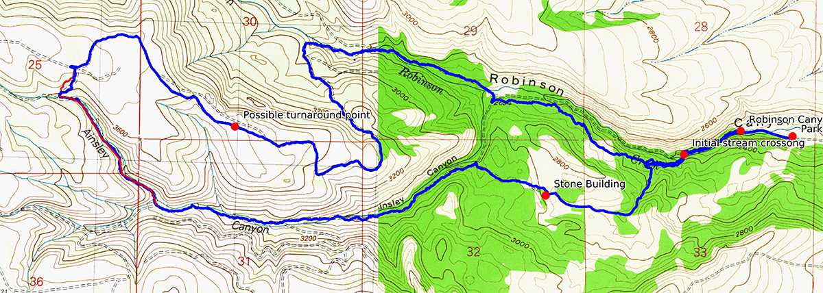
We did a 10 mile counterclockwise loop, going out along Robinson Canyon and returning via Ainsley Canyon. To get from one canyon to the other we went up and across the unnamed plateau that separates them, mostly following the 4x4 track that goes lengthwise along the top. To drop from the plateau down to Ainsley we followed the route of a road that appears on the USGS map (last updated in 1958) but which is no longer there. This required abouts 300 yards of off-trail hiking that ended with a brief step over the headwaters of Ainsley Creek, only about 1 foot wide at that point, and going through about 8 feet of easy brush to reach the trail. This brief stretch of off trail travel allowed us to do the hike as a loop instead of as an out-and-back.

Sections of the trail were very scenic, with highlights including sections of the Ainsley Canyon trail, once a road but now carpeted with Lupine. The walk along the top of the plateau was also nice, with expansive views of the local landscape and pocket views of Ellensburg Valley and the Stewart Range. The Aspen groves were also beautiful when fluttering in the wind, a sight not commonly seen west of the Cascade Crest. The meadow where the abandoned stone house (described in various route descriptions) is also very scenic and welcoming.
However, except for the road across the top of the plateau and the sections of trail within about 1.5 miles of the trailhead, the trail was in poor shape. Some parts of the trail where obvious and very easy to follow, whereas others seemed to have virtually disappeared. Parts of the Robinson Canyon trail furthest from the trailhead were overgrown, and much of the western Ainsley Canyon trail is significantly overgrown and basically invisible in some places. The section of trail that leads from the Robinson/Ainsley intersection to the stone house (described in various route descriptions) is no longer there, having been obliterated by recent logging activity. We saw no trail signs, but some of the 4x4 roads were labeled near the trailhead. We saw about a half dozen animal skeletons along the route and passed some sections of trail still carpeted with pine cones from the previous autumn, which further suggested that we were on trail that had not been visited for a while and which was on the verge of disappearing altogether.
We had two rattlesnake encounters. One was near the trailhead, and rattled at us from several feet off the trail as it withdrew. One large rattler was directly next to the trail near a small waterfall along the Ainsley Canyon trail. It also withdrew, but rattled at us furiously as it did so, which sent a few members of our party scurrying. We had been vigilant about snakes in the high sections of the trail open to the sun but had not been expecting any in the cool, shaded areas below.
Depending on one's perspective, the remoteness and roughness of the trail either created a memorable sense of adventure or could be overwhelming. Though sections of the trail had their charms, overall this route is appears to offer more downside and upside, therefore I do not recommend this route, especially the return trail through Ainsley Canyon. An out-and-back through Robinson Canyon and along the top of the plateau is probably a better alternative. We are fortunate to live in an area with many beautiful trails, and there are better options available than this one.
In spite of some sections of route trail and a couple snake encounters (see Route Conditions) a wonderfully enthusiastic and positive group made this a very fun trip. The temperature was very warm so we took more shade breaks that usual, but otherwise made steady progress and completed the 10 miles/1500' in about 7 hours. We saw no other people the entire hike except when we got back to the cars.
The trails are unmarked and sections are overgrown. On three occasions the trip leader missed a turn -- one of the hazards of lively conversation while hiking -- and the group had to double back a short ways. The group was kind and forgiving of the missteps, but they did increase our mileage and hike time somewhat.
After the hike we went to the Cottage Cafe in Cle Elum, which received a unanimous thumbs up. Highly recommended, especially for the great service.
Even though the high spirits and clear weather made this a fun trip, I'm giving the trip a modest rating of only three starts because of issues with the route. Otherwise it was a fun trip indeed.
 David Bradley