Trip Report
Alpine Scramble - Hawkins Mountain
A warm day with challenging soft snow conditions, but a scenic ridge ascent!
- Fri, May 10, 2024
- Alpine Scramble - Hawkins Mountain
- Hawkins Mountain
- Scrambling
- Successful
-

- Road rough but passable
-
Snow free until 5000 feet, patchy snow until 5200 feet where it becomes constant. On our particular warm day, snowshoes were needed at 5200' but should not be needed on cooler day or later in spring.
WTA report: https://www.wta.org/go-hiking/trip-reports/trip_report-2024-05-16.101841535698
With no previous reports on Hawkins Mountain this year, I picked a beautiful spring day to lead a scramble. Unfortunately, I also picked the warmest day. Low to mid 80's in the lowlands meant 60's-70's on the mountain. We used the western approach from the Camp Creek trailhead. Road was completely clear and snow free and in good shape. We opted to park at the true trailhead at the end of Spur 140, but the road is narrow and parking space is minimal, only space for 3 cars (maybe 4 if one car is small) to leave enough room for a turnaround. We started a little after 9 and hiked up the Boulder-DeRoux Trail briefly until we found the climbers trail. Up we went up the pretty steep trail, which had minimal shade. We got up to a 4450' knoll, but could've avoided it by staying more climber's right and following a path that mores goes though a little gulch to a small saddle.
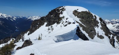
From the knoll/saddle the trail turns east, ascending another big steep hill but with a bit more shade. A bit over 4800 feet there is a place where the trails split but they merge again 200 feet higher. The left trail here is the more direct option. Patchy snow began at 5000 feet and then we hit constant snow at 5200 feet, much lower than I was expecting. And due to the warm temperatures, postholing became a common occurrence as the snow was getting soft so it wasn't too much further until we put on snowshoes, which was far sooner than I was hoping. We would not need snowshoes on this route if the snow wasn't so soft, however. Go on a cooler day and you will not need em. The ridge opens up and leaves the timber, opening up great views of the peak ahead and all the mountains around! But the ridge was warm and bright so reapplying sunscreen regularly was essential. At about 6000 feet the route gets steep again, going up another big steep hill which was taxing in the soft snow. At 6400 feet the ridge levels out again where it meets the Camp Creek Mine Trail (somewhere under all the snow). Then another 600 feet of another steep and slushy hill up to the false summit. From the false summit, there was a big cornice on the east side of the ridge but easily avoidable by staying climbers left. Not all of the group made the summit, but those who did arrived a bit after 2pm, 5 hours from the car to do the 3.25 ish miles. Supreme views all around: Glacier, Stuart, Daniel, Rainier, Adams, and everything in between!
Getting back down the steep hills was even tougher as the snow got really soft and slushy. One person opted to keep the snowshoes off and glissade as much as possible, one person mastered the "snowshoe skiing" technique. Some of us tried to switchback as much as possible to take away the steepness. On the way back down when we reached the saddle at 4400' we made sure to follow the gulch down past the knoll then meet back up with the climbers trail. Got back to the cars around 5:30.
This approach is best in spring and would not want to do it when snow-free and barren. I suggest going sometime in the next 3-4 weeks. Go on a cool day and you won't need snowshoes. No water source on this route, so come prepared.
 Chris Pribbernow