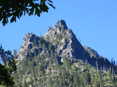
Yellowjacket Tower/East Flank
A steep and direct climbers trail leads to two, fairly short, pitches of mid-5th class rock with a bit of exposure just below the summit. Good views of Icicle Creek valley. Goats occasionally will keep you company and may cause problems. Times: 5 hr trailhead to summit.
getting there
Drive US-2 (Stevens Pass) east to Leavenworth. Just before entering town, turn right on Icicle Creek Road. Follow road 6.1 mi to a turnout on the left near a bridge.
APPROACH
A trail leaves the road near the east end of the turnout down to a private, metal and wood, bridge. After crossing the bridge (l,670 ft) go left on the gravel road (private property) a few hundred feet to where an obvious well worn trail leaves the gravel road on its right. Hike this trail to Rat Creek Boulder then slightly right and up. The trail is obvious, well worn and steep. Follow this trail mainly up (south) until it puts you at the base of the main gully. The base of the main gully is littered with white granite scree that leads up to a very large chock stone obstruction on its left.
Proceed a few hundred feet up to beneath the obstruction. Scramble right out of the gully, then up and left back into the gully to get above the obstruction. Here, the gully becomes very broad and dirty. Continue up the gully past several large fallen trees. Right and up toward the skyline look for a yellowish vertical wall with bubbly granite (large knobs, chicken heads, etc.). This is easier to see looking west from the top of the minor pass. Begin ascending right and toward this structure. Just below its base is a large tree where the start of a steep hidden gully is between the tree and the main wall. Space at the belay ahead is limited so it may be best to rope-up here.
ASCENT ROUTE
Scramble the hidden gully to a belay at a tree on the left and below a right facing dihedral on the right (4,000 ft). The hidden gully is Class 2-3 with one short section of Class 4 climbing, and a rope is recommended. Climb the 70-foot right facing dihedral and exit right past a tree and large chockstone. Then climb left onto the broad base on which the summit tower sits. There are ample space to belay here.
The climb finishes on the west side of the tower by climbing a sloping ramp, a small shelf, and the a short slightly exposed 15 ft section to the top (4,140 ft). Protect this exposed section with a cam in the 1-2 inch horizontal crack at its base. At the top, there is an old iron ring of unknown quality and bolts. Since there is little room at the top, rig the bolts as a top rope anchor to belay the second from below.
DESCENT ROUTE
Descend using double- or single-rope rappels.
TRIP PROFILE
| SEGMENT | TIME (HR) | ELEVATION GAIN (FT) |
|---|---|---|
| Trailhead to Summit | 5 | 2,500 |
| Summit to Trailhead | 3 |
EQUIPMENT
Standard rock equipment. Take a selection of eight to ten stoppers, hexes, and cams for cracks from 3/8 to 2 ½ inches in with most between ½ in and 1 ½ inches.
NOTES
- The approach initially is through private property. Be respectful and quiet.
- The summit block is difficult to protect. Some leaders have used a #0.5 (pink) tricam in a small pocket near eye level to protect the summit block.
- Beware of Mountain Goats in area. They can cause rockfall on approach or climb. Many climbers hang their non-summit packs on trees beyond the reach of the goats.
- Suitable Activities: Climbing
- Climbing Category: Basic Alpine
- Seasons: April, May, June, July, August, September, October
- Weather: View weather forecast
- Difficulty: Technical 3, Basic Rock Climb, Strenuous 1
- Length: 2.5 mi
- Elevation Gain: 2,250 ft
- 4,140 ft
-
Land Manager:
Okanogan-Wenatchee National Forests
Wenatchee River Ranger District (OWNF)
- Parking Permit Required: Northwest Forest Pass
- Recommended Party Size: 12
- Maximum Party Size: 126
- Maximum Route/Place Capacity: 12
- USGS Leavenworth
- Green Trails Leavenworth No. 178
There are no resources for this route/place. Log in and send us updates, images, or resources.
