Whistler
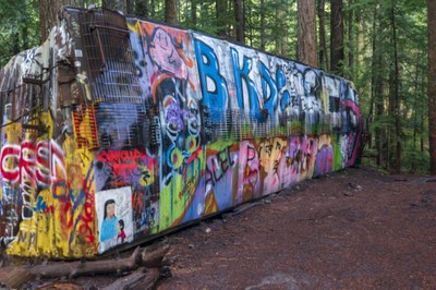
Known for its skiing and the Winter Olympics, the Whistler area in Canada's British Columbia has hiking trails that are a part of its historical and cultural identity. The Train Wreck site is one popular attraction and a great photo opportunity that is located near the Cheakamus River just south of Whistler.
getting there
Whistler Olympic Village is ~75 miles (121 km) north of Vancouver, Canada on British Columbia Highway 99.
on the trail
whistler trails
- Cut Yer Bars Trail: 2.4-mile loop with 429 feet of elevation gain. Difficulty: Easy. Best Season: March through October.
- Lost Lake Nature Trail: 1.7-mile loop with 278 feet of elevation gain. Difficulty: Easy. Best Season: July through November. Also a good snowshoeing destination in winter.
- Whistler Train Wreck: 1.4 miles round trip with 150 feet of elevation gain. Difficulty: Easy. Best Season: May through November. Enjoy old growth forest, a suspension bridge and seven train box cars left over from a wreck in 1956, now painted with artwork and graffiti.
- Ancient Cedars Trail: 2.7 miles round trip with 984 feet of elevation gain. Difficulty: Moderate. Best Season: May through October. Enjoy old growth cedar forest, hunting for mushrooms of every shape and size (October is the best time), and stunning views of snowy mountains and a hidden waterfall that ends in a cluster of yellow cedars.
- Cheakamus Lake Trail: 8.9 miles round trip with 1,318 feet of elevation gain. Difficulty: Moderate. Best Season: April through October. There may still be snow higher up in the earlier months. It's also good for beginner mountain biking and for backpacking/camping (with fee).
- Rainbow Lake Trail: 9.1 miles round trip with 2,709 feet of elevation gain. Difficulty: Strenuous. Best Season July through October. The terrain and bio-zones are varried terrain and bio-zones, but the trail is well-maintained and marked. The trail meanders through forests, flowers, and berry bushes, and across creek bridges and boardwalks.
- Wedgemont Lake Trail: 6.4 miles round trip with 3,937 feet of elevation gain, Difficulty: Strenuous. Best Season: July through September. This is one of Whistler's most difficult trails offering 360° panoramic views of peaks and glaciers, and a waterfall. There are lots of roots and boulders in the first bit of the trail.
- Harmony Lake Trail: 1.7-mile loop with 416 feet of elevation gain. Difficulty: Easy. Hike to a postcard-perfect mountain lake.
Information for Leaders
Considerations for travel to Canada
- Start by reviewing the latest regulations. Look for information on border crossing and travel to Canada on these websites:
- Everyone must have a passport or other valid ID like a NEXUS card.
- NEXUS cards can save a lot of time but only work if everyone in the car has one.
- Make sure your vehicle insurance is valid for Canada.
- Make sure your health insurance is valid for Canada.
- Border crossing regulations are strict in both directions. Know what you’re allowed to take and declare everything to avoid problems.
- You may be able to save time by checking alternate border crossings.
- See the Travel Industry Council of Ontario's 9 Travel Tips for Crossing the Canadian/U.S. Land Border blog post for some good tips on traveling to Canada.
- Suitable Activities: Day Hiking
- Seasons: Year-round
- Weather: View weather forecast
- Difficulty: Easy, Moderate, Strenuous
- Length: 2.8 mi
- Elevation Gain: 150 ft
- 2,047 ft
- Land Manager: Land Manager Varies
- Parking Permit Required: see Land Manager
- Recommended Party Size: 12
- Maximum Party Size: 12
- Maximum Route/Place Capacity: 12
- Green Trails Whistler No. 92J1S
This is a list of titles that represent the variations of trips you can take at this route/place. This includes side trips, extensions and peak combinations. Not seeing a title that fits your trip? Log in and send us updates, images, or resources.
- Whistler Trails
- Whistler Village
- Whistler Olympic Village
- Cut Yer Bars Trail
- Cut Yer Bars Loop
- Lost Lake Nature Trail
- Whistler Train Wreck
- Ancient Cedars Trail
- Cheakamus Lake Trail
- Rainbow Lake Trail
- Wedgemont Lake Trail
- Harmony Lake Trail
- Harmony Lake Loop
There are no resources for this route/place. Log in and send us updates, images, or resources.
