Westberg Trail
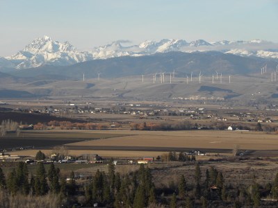
An easy, 4.0-mile round trip hike with 1,700 feet of elevation gain. Ascend an open, rocky gully to a ridge-top memorial with views of the Kittitas Valley, the Cascades, and Mount Stuart. It can be done as an out-and-back or a loop. This is a dog-friendly hike.
getting there
Take Exit 101 off of I-90 and turn onto Thorp Highway S. Turn right onto Cove Road. Continue to the parking area about 100 yards past the intersection with Manastash Road (2,000 ft).
on the trail
Hike the Westberg Trail, an old jeep trail. It splits in ~0.3 mile. Take either fork and continue steeply to Manastash Ridge and the memoral site (3,141 ft). Enjoy amazing flower displays, birds, and butterflies in late spring, and spectacular views from the ridgetop into the Kittitas Valley, the Cascades, and Mount Stuart.
notes
- Watch for rattlesnakes.
- This trip can be done a loop with the flower-filled ascent through an open, somewhat steep, rocky gully, lunch along the ridgetop, and descent through a forested area with a small stream or seep early in the season.
- The University of Washiongton's Manastash Ridge Observatory is another 1 mile west along the rocky ridge.
- Suitable Activities: Day Hiking
- Seasons: April, May, June, July
- Weather: View weather forecast
- Difficulty: Easy/Moderate
- Length: 4.0 mi
- Elevation Gain: 1,700 ft
- 3,560 ft
- Land Manager: Wenas Wildlife Area
- Parking Permit Required: Discover Pass
- Recommended Party Size: 12
- Maximum Party Size: 12
- Maximum Route/Place Capacity: 12
- WA DNR Yakima
- USGS Manastash Creek
- Green Dot Maps (wdfw.wa.gov)
There are no resources for this route/place. Log in and send us updates, images, or resources.
