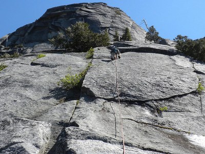
Exfoliation Dome/West Buttress
Also known as the Blueberry Route, this is an 8 to 10 pitch, 5.9 trad route on the west wall of Exfoliation Dome outside of Darrington. An alpine-setting climb with a shorter approach for advanced climbers.
getting there
Take Exit 208 off of I-5. Drive ~32 miles to the east on SR-530 to Darrington. Drive to the center of town, turn right at the four-way stop onto the Mountain Loop Highway, and drive south for 2.9 miles. Just before Clear Creek Campground, turn right onto Forest Road 2060 which is gravel and dirt. At mile 5.5 reach an intersection, turn left onto Forest Road 2065 (Blueberry Hill Road), and drive for ~2 miles past the first washout. Park ~50 feet past the second drainage. There is a pullout on the right with room for about four cars. On a clear day, the dome should be visible.
APPROACH
Hike up the creak bed heading east. After 10 minutes reach a continuous 20-degree slab of granite leading all the way up to the base of the dome. This is known as the Granite Sidewalk. Travel is mostly low angle Class 2 slab with a couple short Class 3-4, 8-foot high sections that must be scrambled.
ascent
Pitch #1 - 5.5, 130 ft - Scramble up the offwidth (Class 4) then keep moving up low angle face and cracks until a ledge at the base of the obvious left facing corner.
Pitch #2 - 5.7, 180 ft - Lieback up the corner and turn to the roof and undercling it to the left (very fun climbing, about 5.5). Stay on the top level and jamb and lieback up the low angle dihedral (starts as 5.7 and then gets easier) using the crack at your feet for pro. Continue all the way up to the ledge with the tree to belay.
Pitch #3 - 5.9, 150 ft - This is the crux pitch, and used to be rated 5.8 until the big flake fell off in 2004. Climb the right facing corner on the right side of the buttress. The going gets interesting after about 20 feet. Clip the two bolts where there is no crack, then stem and face climb up the thin dihedral. Keep moving up until things get difficult and mossy, then climb to the top of the arête, a good belay ledge. Belay here using the 3-inch crack for an anchor.
Pitch #4 - 5.7, 230 ft - This excellent pitch is long and varied. Climb the 3-inch crack then turn the corner to the left. Climb the chimney behind the flake, then climb directly up the middle of the face via a series of angling crack and flake systems. This pitch is very continuous. For a belay there are a few options:
- Bring 70 meter ropes to reach the nice ledge with the tree.
- Do a hanging belay off crack systems at 60 meters.
- Simulclimb for 30 feet until the leader reaches the nice ledge.
Pitch #5 - 5.5, 190 ft - Climbs slabs and corners up the buttress crest. Belay where feasible.
Pitch #6 - 5.4, 100 ft - Finish climbing slabs and corners up the crest and belay at the big ledge in the trees.
Traverse to climbers left over Class 2 terrain with one short Class 4 section until you can see around the corner. Keep traversing until the rock gets steeper. Look up about 20 feet for a positive sloping ledge. Climb Class 3+ rock up to the ledge. There is a good crack on the left and flake on the right for an anchor.
Pitch #7 - 5.8, 185 ft – Climb up some cracks with occasional brush in them to gain the slab above. Use every opportunity for pro as protection is limited on this pitch, and there are no bolts. Climb slab and cracks directly up the crest of the buttress. Belay points are limited. There is a good gear belay at about 185 feet.
Pitch #8 - 5.6 – Continue moving up the buttress crest until you can traverse off to the left towards the ridgeline. Belay where feasible.
descent
Rappel the West Slabs route. Described well in Weekend Rock Washington (below).
notes
- The slab on the approach is dangerous if wet or covered with moss or snow. An alternative if it rains while descending is to bushwack down through the forest next to the Granite Sidewalk.
- You'll want a 70m rope or lots of creativity for this climb.
- Can be done in ten pitches. See Weekend Rock Washington (below) for ascent and descent variations.
- Suitable Activities: Climbing
- Climbing Category: Intermediate Alpine
- Seasons: May, June, July, August, September, October
- Weather: View weather forecast
- Difficulty: Intermediate Rock Climb
- Length: 3.0 mi
- Elevation Gain: 1,000 ft
- 4,235 ft
-
Land Manager:
Mount Baker-Snoqualmie National Forest
Darrington Ranger District (MBSNF)
- Parking Permit Required: Northwest Forest Pass
- Recommended Party Size: 6
- Maximum Party Size: 12
- Maximum Route/Place Capacity: 12
- Green Trails Silverton No. 110
- USGS Helena Ridge
There are no resources for this route/place. Log in and send us updates, images, or resources.
