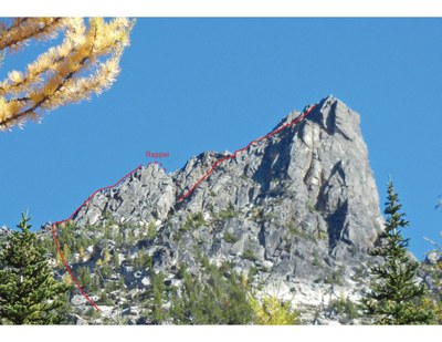
Vasiliki Tower/Northwest Face
Two pitches about 5.3 to 5.4 rock climbing on a tower approached from Burgundy Col near Washington Pass. It's a face climb approximately 40 feet right of the Northwest Dihedral route on Vasiliki Tower.
Getting There
Drive east on SR-20 (North Cascades Highway) to Washington Pass. Continue to mile marker 166 near the sign pointing to Silver Star. Park here at pull-off about 4 miles east of Washing ton Pass.
approach
Head down embankment and cross Early Winters Creek on logs. Ascend climber's trail on timbered rib left of Burgundy Creek, which drains the basin. Easy bushwhacking if trail cannot be found. Camp in a bench around 6,400 ft near the creek or at the bivy sites at Burgundy Col (7,800 ft). Water is available at both sites until late summer.
If you bivy at Burgandy Col, traverse around Vasiliki Tower to the north side. If you camp below the col or climb this in a day, stay to left and approach to north side of the tower.
Before reaching the north ridge scramble to crest the rib on climber's right. Rappel into a gap between the rib and the tower. The route begins across from the bottom of the rappel. Gear can be stashed at the top of the rappel.
It is also possible to climb the gap between the rib and the tower, but the gully between is narrow with loose rock and not good for a large party.
Ascent
The first pitch starts with an easy face climb to left trending rising ledge. Ascend the ledge just far enough to continue on the face. If you stay on the ledge it will lead toward the north ridge. Continue face climbing to a sandy bench.
The second pitch starts about 10 feet left (west) on the bench. A slab with a good fingers crack on the left side makes for good climbing with good pro. The slab leads directly to the summit.
The first pitch is about 50 m and the second about 30 m.
Descent
Down climb the north ridge. No rappels should be needed. The north ridge leads to the rappel station and stashed gear can be picked up and the rappel cleaned.
Trip Profile
Seattle to Trailhead 3.5 hours
Trailhead to Col 2-4 hours 2500' gain
Col to Summit 4 hours 500' gain
Summit to Col 1 hour
Col to Trailhead 2 hours
Equipment
Standard Rock Equipment
notes
- As with Silverstar, this may be done as a one day trip with a car-camp at the pull out, or as an overnight trip camping near the Burgundy Col.
- Since this is a new addition to the climbs for 2025, basic students should have at least one successful rock climb before attempting this route.
- Suitable Activities: Climbing
- Climbing Category: Rock Climb
- Seasons: July, August, September
- Weather: View weather forecast
- View avalanche forecast.
- Difficulty: Strenuous, Basic Experience Climb
- Length: 2.0 mi
- Elevation Gain: 3,850 ft
- 7,920 ft
- Land Manager: Okanogan-Wenatchee National Forests
- Parking Permit Required: None
- Recommended Party Size: 6
- Maximum Party Size: 6
- Maximum Route/Place Capacity: 12
- USGS Silver Star Mtn
- USGS Washington Pass
- Green Trails Washington Pass No. 50
There are no resources for this route/place. Log in and send us updates, images, or resources.
