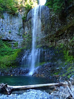
Unicorn Creek - (MRNP)
Incredibly scenic views of Mt. Rainier, with an optional 9th rappel down iconic Martha Falls, within Mount Rainier National Park. (Paradise Side) - Please be aware of any entry restrictions / requirements.
Please check Ropewiki for most current Beta & Route:
https://ropewiki.com/Unicorn_Creek
Taken from Ropewiki:
Unicorn Creek is located in the Tatoosh Range within Mount Rainier National Park, east of Paradise just off Stevens Canyon Road. It is the outlet of Snow Lake (elev. 4,688 ft), which is recharged by the Unicorn Glacier above (actually a semi-permanent snowfield). The creek descends 1,300ft in just under a mile. Columnar basalt is prevalent throughout. The character of the creek begins casually and gains momentum, culminating in the spectacular Martha Falls amphitheater just before the confluence with Stevens Creek.
- Much of Unicorn Creek can be seen from across the canyon along Stevens Canyon Road (GPS point for pull out is 46.7707, -121.6898). This is also where the reference picture is taken.
- Watershed: 1.25mi^2. The creek drains a north-facing snowfield. The high point in the drainage is Unicorn Peak at about 6900ft elevation.
- Please plan for any potential entry restrictions for Mount Rainier National Park.
- Suitable Activities: Canyoning
- Seasons: June, July, August
- Weather: View weather forecast
- Length: 2.1 mi
- Elevation Gain: -1,160 ft
- Land Manager: Mount Rainier National Park
- Parking Permit Required: National Park Entrance Fee
- Recommended Party Size: 8
- Maximum Party Size: 12
- Maximum Route/Place Capacity: 12
This is a list of titles that represent the variations of trips you can take at this route/place. This includes side trips, extensions and peak combinations. Not seeing a title that fits your trip? Log in and send us updates, images, or resources.
- Unicorn Creek & Martha Falls - MRNP
There are no resources for this route/place. Log in and send us updates, images, or resources.
