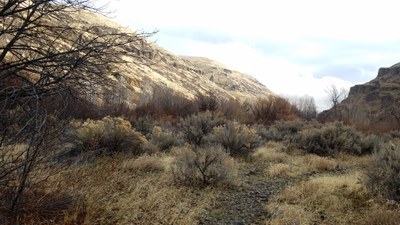
Umtanum Creek Canyon
A 6-10 mile moderate hike with less than 700 feet of elevation gain through the lush Umtanum Creek Canyon. Hike through tall canyon walls looking for flowers blooming and wildlife who come to drink from the creek.
getting there
Take Exit 3 off of I-82 and turn right onto SR 821. At the next stop sign turn left to stay on SR 821 and continue 8 miles to the Umtanum Recreation Area after Milepost 16. Park in the gravel lot west of the highway.
Parking: The parking lot is managed by the BLM (U.S. Department of the Interior's Bureau of Land Management). The day use paking fee may be paid at the self-service fee station. Visit the BLM Permits and Passes website for other options.
on the trail
The trail is on the left after walking below the railroad bridge which is accessed by the suspension bridge over the Yakima River from the parking lot. Hike towards the large information board located at the fork on the trail within 200 feet from the rail tracks and take the trail on your right.
After about 3/4 of a mile, the trail splits with boulders on your left. Take the right fork, which crosses the stream. After crossing the stream, look for the trail heading to the west and avoid other side trails leading to the east. The trail runs through outgrown bushes and woods, so some bushwhacking may be needed.
About a mile from the first creek, reach another fork. Take the left fork and cross the stream again. A small section of the trail after this crossing is through the rocks and traverses a scree slope. Soon after this and about 3 miles from the trailhead, the trail narrows. This is good point to run around.
While heading back to the parking lot, be aware of the side trails and avoid them. Between the two crossings, take the left fork just before the last crossing.
- Suitable Activities: Backpacking, Day Hiking
- Seasons: January, February, March, April, May, November, December
- Weather: View weather forecast
- Difficulty: Easy/Moderate
- Length: 6.0 mi
- Elevation Gain: 700 ft
- 2,000 ft
- Land Manager: Wenas Wildlife Area
- Parking Permit Required: BLM Permits & Passes
- Recommended Party Size: 12
- Maximum Party Size: 12
- Maximum Route/Place Capacity: 12
- USGS Wymer
- USGS The Cottonwoods
- WA DNR Yakima
- Green Dot Maps (wdfw.wa.gov)
There are no resources for this route/place. Log in and send us updates, images, or resources.
