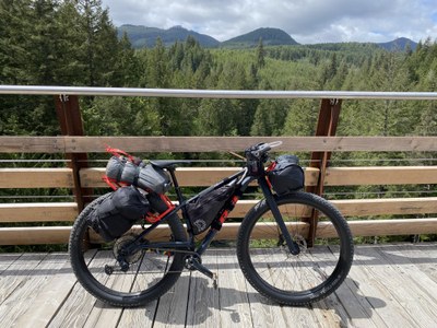
The B.C. Kootenays Slam
An exploration of some of the local bikepacking routes out of Nelson, British Columbia. This slam combines both the Santa Rosa Valleys and Vistas route with the Frog Peak Loop for a total of 196 miles of bikepacking fun in beautiful British Columbia.
Getting There
From Seattle, drive U.S. Highway 2 east towards Wenatchee. From Wenatchee, take HW 97 north to Tonasket. From Tonasket, follow HW 20 east to Torboy and continue north on HW 21 to the Canadian border, just past Danville, WA. Cross the border arriving in Carson, B.C. Then head east/northeast on HW 3, 3A, and 6 until you reach Nelson, B.C.
On the route
Slam Part 1: The Santa Rosa Valleys and Vistas Route (130mi/13,949ft gain)
The route begins in the town of Castlegar, B.C., just outside of Nelson. Starting from Castlegar, this loop route travels counterclockwise. The riding terrain includes paved highway, paved rural road, gravel double track, and gravel and dirt single track.
Suggested Itinerary
- Day 1: Castlegar to Bulldog Tunnel (24 mi/3047 ft)
- Day 2: Bulldog Tunnel to Santa Rosa Creek Recreation Site (52 mi/5882 ft)
- Day 3: Santa Rosa Creek Recreation Site to Rossland (22 mi/3982 ft)
- Day 4: Rossland to Castlegar (32 mi/1745 ft)
Slam part ii: the frog peak loop
The route begins in Nelson and travels counterclockwise. The route riding terrain includes paved highway, paved rural road, gravel double track, and gravel and dirt single track.
Suggested Itinerary
- Day 1: Crescent Valley to Six Mile Lakes (31 mi/3917 ft)
- Day 2: Six Mile Lakes to Crescent Valley (34 mi/1148 ft)
Camping and Water
Developed, primitive, and dispersed campsites are plentiful along the route. Water is easily available at campsites, creeks, and lakes along the route.
Essential Gear and skills
A hardtail mountain bike with a minimum of 2" tires is recommended for this route due to some sections of chunky trail and technical single track. Riders should have proficient mountain biking skills for the unpaved sections of this trail.
More information
For more information on the route, photos, and GPS go to:
- https://bikepacking.com/routes/santa-rosa-valleys-and-vistas/
- https://bikepacking.com/routes/frog-peak-loop/
- Suitable Activities: Bikepacking
- Seasons: June, July, August, September
- Weather: View weather forecast
- Difficulty: Bikepacking Gravel III, Bikepacking MTB III
- Length: 196.0 mi
- Elevation Gain: 18,887 ft
- 5,288 ft
- Land Manager: Land Manager Varies
- Parking Permit Required: see Land Manager
- Recommended Party Size: 8
- Maximum Party Size: 12
- Maximum Route/Place Capacity: 12
This is a list of titles that represent the variations of trips you can take at this route/place. This includes side trips, extensions and peak combinations. Not seeing a title that fits your trip? Log in and send us updates, images, or resources.
- Frog Peak Loop
There are no resources for this route/place. Log in and send us updates, images, or resources.
