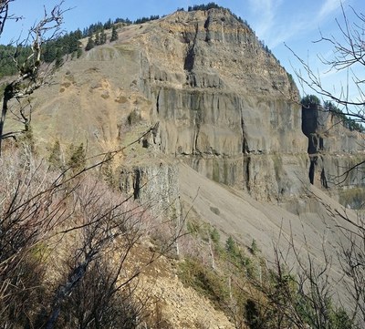
Table Mountain (Columbia River)
A very strenuous hike in the Columbia River Gorge on the Washington side near Bonneville Dam. The top of Table Mountain features one of the best panoramas of the Columbia River Gorge, as well as views of Mount St. Helens, Mount Rainier, Mount Hood and Mount Adams. Most of the 4,320 feet of elevation gain is in the last two miles. Table Mountain's dramatic south face and pyramid profile beckon the adventurous hiker ready for a strenuous climb that is good training for summer summit attempts.
getting there
Drive SR-14 39.7 miles east from Vancouver, WA and turn right into the Bonneville Trailhead (140 ft).
- Suitable Activities: Day Hiking
- Seasons: April, May, June, July, August, September, October
- Weather: View weather forecast
- View avalanche forecast.
- Difficulty: Very Strenuous
- Length: 15.5 mi
- Elevation Gain: 4,320 ft
- 3,450 ft
- Land Manager: Columbia River Gorge National Scenic Area
- Parking Permit Required: Northwest Forest Pass
- Recommended Party Size: 12
- Maximum Party Size: 12
- Maximum Route/Place Capacity: 12
- Green Trails Columbia River Gorge West No. 428S
- Green Trails Bonneville Dam No. 429
- Trails Illustrated Columbia River Gorge
This is a list of titles that represent the variations of trips you can take at this route/place. This includes side trips, extensions and peak combinations. Not seeing a title that fits your trip? Log in and send us updates, images, or resources.
- Table Mountain
- Table Mountain Loop
- Table Mountain Loop (Columbia River)
There are no resources for this route/place. Log in and send us updates, images, or resources.
