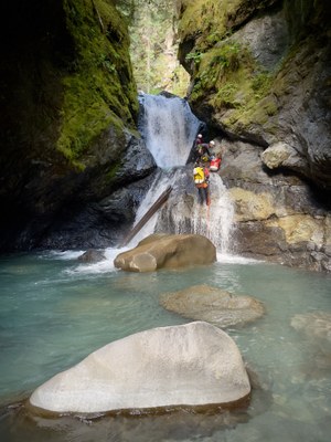
Swamp Creek
Don't let the name fool you! Swamp Creek is in fact a fun and scenic canyoning route, located in the North Cascades off of the Mt. Baker Highway. This Intermediate canyon has a little bit of everything, from rappels, jumps, a slide or two, and plenty of downclimbs through the unique geology in between. This route is best run starting in mid August, and typically runs v3 a3 III.
Getting There
From Glacier, WA, head 13 miles east on the Mt. Baker Highway (SR-542). Take a left at NF-32 road (48.90654, -121.69362). Continue for about 0.4 miles and take a left onto one of several side roads. These roads lead back to primitive campsites near Swamp Creek. If these campsites are occupied, it is possible to park along the main road.
Shuttle
Head back out to the Mt. Baker Highway and turn right. After several hundred feet, take another right onto FR-3065 (towards Twin Lakes trailhead). Drive about two miles up the gravel road and turn right onto a side road (48.91706, -121.68105). This road dead ends after a few hundred feet and can fit 2-3 vehicles. Park and suit up here.
Descent
From the parking area, there is a use trail down to the creek that only takes a few minutes and begin scrambling down the creek. Within a few minutes you’ll reach the first obstacle as the creek starts to become more narrow.
J1: 5’ jump into shallow pool. This drop can be down climbed or bypassed DCR.
R1: 15’ from a log.
R2/J2: DCR - Traverse 15’ to 25’ rappel, both from unlinked bolt anchors. This rappel puts you directly in the flow, and has also been jumped.
R3: 18” from a log.
There is some exposed down climbing to reach the R4 anchor.
R4: DCR - 25’ dry rappel from a single bolt.
After R4 there is a good stretch of scrambling and downclimbing. Keep an eye out for a pothole where the water seems to disappear!
R5: DCL - 50’ from unlinked bolts. This rappel takes you down a giant log wedged in the creek. There is a large pothole hidden beneath the log. Take special care not to swing into this pothole while on rope.
R6/S1: DCR - 60’ from unlinked bolts. This drop also goes as a slide from about half way down. It is possible to scramble back up from the bottom to do this slide.
R7/J2: DCR - 25’ from unlinked bolts. This drop has also been jumped into the narrow pool below.
Directly after R7, down climb DCR, or scramble across the creek and do an optional rappel off of a log for a more secure route down.
R8: 15’ from a logjam. This drop has been down climbed.
R9: DCR - 40’ from a single bolt on a boulder.
R10: DCL - 35’ from a V-thread into a pool. It is important to set rope length here to avoid entanglement. There is an alcove on canyon left that less confident swimmers can be pushed into. Sending a strong swimmer first to assist others out of the pool is recommended.
R11: DCL - 15’ from a single bolt.
Exit
After R11, continue down the creek for another 5-10 minutes until the creekbed opens up. Find a spot to cut up into the woods DCL and find the use trail that will take you to the campsites/parking area next to the creek.
Other
While this canyon overall is very straightforward, participants should be confident and efficient downclimbers on slippery terrain, and be confident rappelling in flow. The canyon is committing in some sections, while there are possible escape routes where the canyon opens up.
- Suitable Activities: Canyoning
- Seasons: August, September
- Weather: View weather forecast
- Length: 0.9 mi
- Land Manager: Mount Baker-Snoqualmie National Forest
- Parking Permit Required: Northwest Forest Pass
- Recommended Party Size: 8
- Maximum Party Size: 12
- Maximum Route/Place Capacity: 12
There are no resources for this route/place. Log in and send us updates, images, or resources.
