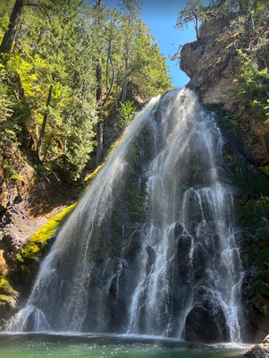
Summit Creek
Summit Creek Canyon offers a diverse canyoning experience, with the Middle Summit Creek section providing a short but delightful adventure, starting at the former Summit Creek Campground and concluding just past Thunder Falls. For the more ambitious, the entire Summit Creek can be tackled in a lengthy day or split over two days to cover the Upper and Lower sections.
GETTING THERE
The decommissioned Summit Creek Campground serves as the starting point for the Middle section, with no shuttle required. For the Upper and Lower sections, a shuttle setup is necessary. Soda Springs Campground, operational and only a 10-minute drive away, is an excellent base for exploring Summit Creek and surrounding canyons.
APPROACH
The approach to the Middle section begins at the old campground or the bridge crossing the creek and ends shortly after Thunder Falls. For the Upper and Lower sections, a shuttle is required.
DESCENT
- Upper Section: 3 miles, 5-5.6 hours, 3-4 rappels with a maximum of 80 feet. The first rappel is Fish Ladder Falls, located about 1.5 miles from the start.
- Middle Section: 0.1 miles, adds 1-2 hours, 2-3 rappels with a maximum of 120 feet. Access to R2 & R3 is possible from above with a short rappel.
- Lower Section: 3 miles, adds 4-6 hours, 4 optional short rappels that can be bypassed/jumped, and extensive scrambling/downclimbing.
EXIT
- Middle Exit: After Thunder Falls, locate a memorial plaque on a rock DCR. Across the creek, find a DCL moss-covered talus field to climb up.
EQUIPMENT
Standard canyoning gear is recommended, including replacement webbing and quick links. A hand line may be useful for safety.
TRIP PROFILE
- Rappels: Varies by section
- Longest Rappel: 120 feet (Thunder Falls)
- Approach: Varies by section
- Exit: Middle Exit involves a climb up a talus field to an established trail that fronts the canyon.
- Time: 2 hours for Middle Summit. 12-14 hours for the full canyon; varies for individual sections
NOTES
The Middle Summit Creek section is a brief but enjoyable part of the canyon, ideal for those with limited time. The full Summit Creek descent is a more demanding endeavor, suitable for experienced canyoneers. Combining Upper and Middle or Middle and Lower make for an enjoyable canyoning day! Always check the depth before jumping and be cautious of changing water conditions. For the latest conditions, reference photos and trip reports are invaluable. Remember to respect the natural environment and practice safe canyoning techniques.
- Suitable Activities: Canyoning
- Seasons: Year-round, July, August, September
- Weather: View weather forecast
- Difficulty: Basic Canyon
- Length: 1.0 None
- Land Manager: Gifford Pinchot National Forest
- Parking Permit Required: Northwest Forest Pass
- Recommended Party Size: 6
- Maximum Party Size: 12
- Maximum Route/Place Capacity: 12
There are no resources for this route/place. Log in and send us updates, images, or resources.
