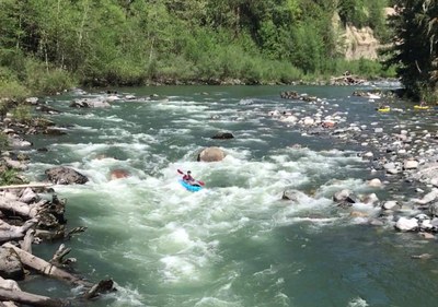
Stillaguamish River (South Fork): Boardman Creek to Verlot
Also known as the "Silly Stilly," this is a classic Class III river run with consistently interesting rapids near the Mountain Loop Highway.
Flow
- NOAA Gauge: SF Stillaguamish--Near Granite Falls (GFLW1)
- 5.5-6.5 feet: Class III. Generally not done below 5.5 feet and said to be pushy above 6.5 feet.
Put-In
- Boardman Creek: The most commonly used put-in. There is parking for six cars southwest of the Boardman Creek Bridge. Carry boats along the south side of the road then climb down below the bridge. Launch under the bridge on the west shore of Boardman Creek.
- Red Bridge Campground
Take-Out
- Verlot: Take out at a 30-foot sandy beach on the north shore just downstream from the Verlot Campground and near Benson Creek. From the beach, a trail leads into the forest then west 0.2 miles to the parking on the south side of Mountain Loop Highway across from the Verlot Public Service Center. There is ample parking here, and there see restrooms at the service center.
On The River
The "Silly Stilly" run is continuously fun 3rd class. There are frequent boulder garden drops interspersed with slower sections. There are two significant rapids that can be scouted from the road.
wiley Creek Ledge
GPS: 48.06987, -121.71727
Wiley Creek Ledge is the most challenging rapid in this section. It starts with a boulder garden then a ledge drop. It is common to run this rapid on river left and then cut right through the drop. There is a good eddy above to pull out and scout. Below more eddies offer a place to regroup. The rapid can be bypassed by climbing up to the road. Will Creek Ledge can be scouted from the road—park in a small pullout at Mile 14.6 on the road's north side, a bit downstream from the ledge.
Ski Jump
GPS: 48.08643, -121.76164
Ski Jump is a series of large standing waves below a boulder field. The wave train may be exited to the left, into a good eddy. Avoid the logs near the river bank to wave train's right. Ski Jump can be scouted from the road. A short distance from Verlot, park in a small pull-out southwest of the bridge across South Fork Stillaguamish River, and walk to the north side of the bridge. Ski Jump is just upstream from there.
notes
- Learn more on American Whitewater's Stillaguamish, S. Fork: 2 - Mallardy Creek to Verlot (Middle) (Silly Stilly) web page.
- Because there is no cell phone coverage at Verlot, it is common to meet in Granite Falls.
- Suitable Activities: Packrafting
- Seasons: Year-round
- Weather: View weather forecast
- Difficulty: Class III River
- Length: 8.0 mi
- 1,240 ft
-
Land Manager:
Mount Baker-Snoqualmie National Forest
Darrington Ranger District (MBSNF)
- Parking Permit Required: Northwest Forest Pass
- Recommended Party Size: 12
- Maximum Party Size: 12
- Maximum Route/Place Capacity: 12
- Green Trails Mountain Loop Highway No. 111SX
This is a list of titles that represent the variations of trips you can take at this route/place. This includes side trips, extensions and peak combinations. Not seeing a title that fits your trip? Log in and send us updates, images, or resources.
- Silly Stilly
- South Fork Stillaguamish River: Silly Stilly
There are no resources for this route/place. Log in and send us updates, images, or resources.
