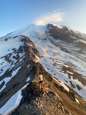
Steamboat Prow Loop from Sunrise
A 16+ mile loop with nearly 7,000 feet of elevation gain and loss that ascends and descends the north and south ridges of Steamboat Prow with an incidental summit of Mount Ruth. A challenging trip on Mountain Rainier's northern flank that's been done as a trail run.
Getting There
From SR-410, turn into Sunrise Road and enter Mount Rainier National Park at the the White River entrance. Follow Sunrise Road until it ends at the Sunrise Visitor Center (6,400 ft).
On the Trail
From Sunrise, hike the Sourdough Ridge trail to the junction with Burroughs Mountain Trail. From Third Burroughs, descend the ridge headed toward Steamboat Prow. Stay on the ridge except to pass any major obstacles, diverting to the north side of the ridge to circumnavigate them. Once atop Steamboat Prow, descend it via the South Ridge through Camp Curtis, up and over Mount Ruth, and follow the old mining trail back to Glacier Basin. Cross White River to its north shore and follow the Glacier Basin Trail to White River Campground. Hike the Wonderland Trail gaining the final 2,200 feet of elevation back to Sunrise.
- Suitable Activities: Scrambling, Trail Running
- Climbing Category: Intermediate Alpine
- Seasons: July, August
- Weather: View weather forecast
- Difficulty: Strenuous 5, Technical 3, Advanced Ultra 2
- Length: 16.0 mi
- Elevation Gain: 6,945 ft
- 9,700 ft
- Land Manager: Mount Rainier National Park
- Parking Permit Required: National Park Entrance Fee
- Recommended Party Size: 2
- Maximum Party Size: 2
- Maximum Route/Place Capacity: 2
- Green Trails Mount Rainier Wonderland No. 269SX
- USGS Sunrise
There are no resources for this route/place. Log in and send us updates, images, or resources.
