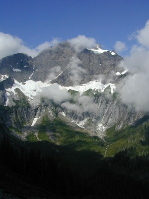
Squire Creek Pass
A 5.4 mile unmaintained hike with 2,900 feet of elevation gain along Squire Creek. The trail follows 2 miles of road turned to boot-built tread, ascends through a section of old-growth timber and breaks out into a traverse of a ridge across from the splendor of the glaciated cirque below Three Fingers.
on the trail
The first two miles of trail are over a road that was cut off by a landslide in 2002. It has now reverted to boot-built tread that has washed away in places but is generally easy to follow. At the old trailhead, cross a stream on rocks and continue on the road another quarter of a mile to the start of a section of trail through old-growth timber. Several washed out sections are flagged. At the end of the trees the trail emerges onto a rocky talus and boulder ridge that is easy to find in places and marked by cairns in others. At the end of the ridge ascend switchbacks to 4,000 foot Squire Creek Pass.
- Suitable Activities: Day Hiking
- Seasons: May, June, July, August, September, October
- Weather: View weather forecast
- Difficulty: Strenuous
- Length: 10.8 mi
- Elevation Gain: 2,900 ft
- 4,000 ft
-
Land Manager:
Mount Baker-Snoqualmie National Forest
Boulder River Wilderness, Darrington Ranger District (MBSNF)
- Parking Permit Required: None
- Recommended Party Size: 12
- Maximum Party Size: 12
- Maximum Route/Place Capacity: 12
- Green Trails Silverton No. 110
There are no resources for this route/place. Log in and send us updates, images, or resources.
