Source Lake
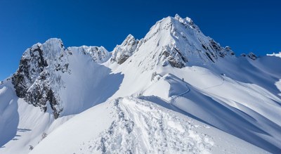
A snowshoe and ski trip trip near Snoqualmie Pass to a lake that is a destination on its own or the starting point for adventures like a winter scramble of Wright Peak or a circumnavigation of Chair Peak. Enjoy Views of Guye Peak, Denny Peak, The Tooth, and Chair Peak.
getting there
Take Exit 52 off of I-90, and turn north off the exit onto SR-906. Drive ~1.2 miles to the Alpental Ski Area parking lot and trailhead (3,100 ft).
Winter Routes
Source Lake (4,100 ft)
5.0 miles round trip, 1,000 feet of elevation gain, difficulty: Moderate Intermediate Snowshoe
Ascend the winter route on the south side of the South Fork of the Snoqualmie River to Source Lake.
Chair Peak Circumnavigation
8+ miles round trip, 4,500 feet of elevation gain, difficulty: M2 Advanced ski
A local classic which a good heaping of vertical travel and some committing terrain. Check the avalanche forecast, because this ski tour includes avalanch-prone couloirs and slopes. The counter clockwise route starts in the Alpental Valley, traverses above Source Lake to the Chair Peak basin near start of the Southeast Buttress climbing route. From here the route descends north and west to Snow Lake, up and around Chair Peak Lake, up and over Kaleetan Pass into the Melakwa Lakes Basin. Finally, the route goes up and over Bryant Pass and then descends to the Alpental Basin. On a sunny days, consider travelling route clockwise to ascend the southern-facing slopes early and before the sun has a chance to soften them too much.
Wright Mountain (5,430 ft)
12 miles round trip, 3,500 feet of elevation gain, difficulty: winter scramble or M2 Advanced Ski
From the Alpental parking lot, ascend the winter route on the south side of South Fork of the Snoqualmie River, cross frozen Snow Lake, pass Gem Lake, and ascend Wright Mountain. As time and conditions permit, ski the north-facing runs from Wright Mountain.
Summer Routes
See our Snow & Gem Lakes route/place for summer hiking, backpacking, and some scrambling Routes & Places that start at Alpental.
Information for Leaders
Scheduling & Permits
- If you are scheduling this as a non-course related activity, please limit your group size to the default party size. The maximum party size is for use by course field trips only, and includes both students and instructors. Group size maximums do not reflect how course field trips are run (in smaller groups of students and instructors), but allow for course leaders to register the course in our system.
- This route allows multiple bookings. Please check scheduled trips listed below in the "Activities" tab to see if there is another group already booked on the same day. If so, please coordinate with them to ensure you are carpooling and teaching at different areas.
- If you are scheduling a course field trip, please contact our Member Services Team to confirm the field trip and any permitting regulations.
Permit information (Snoqualmie Ranger district)
As of 2017, the Snoqualmie Ranger District considers Mountaineers trips and courses to be "nominal use". Leaders should print and copy this designation letter to show rangers they may see on trail or carry a digital copy on their phone.
- Suitable Activities: Backcountry Skiing, Scrambling, Snowshoeing
- Snowshoeing Category: Intermediate
- Seasons: January, February, March, April, December
- Weather: View weather forecast
- View avalanche forecast.
- Difficulty: *Varies*, Moderate, M2 Advanced Ski, Winter Scramble
- Length: 5.0 mi
- Elevation Gain: 1,000 ft
- 4,100 ft
-
Land Manager:
Mount Baker-Snoqualmie National Forest
Snoqualmie Ranger District (MBSNF)
- Parking Permit Required: Northwest Forest Pass
- Recommended Party Size: 12
- Maximum Party Size: 100
- Maximum Route/Place Capacity: 100
- Green Trails Snoqualmie Pass No. 207
- USGS Snoqualmie Pass
- Green Trails Snoqualmie Pass Gateway No. 207S
This is a list of titles that represent the variations of trips you can take at this route/place. This includes side trips, extensions and peak combinations. Not seeing a title that fits your trip? Log in and send us updates, images, or resources.
- Chair Peak Circumnavigation
- Wright Mountain
There are no resources for this route/place. Log in and send us updates, images, or resources.
