Skookum Flats
A moderate day hike along the west bank of the While River. It's 11 miles round trip but relatively flat with a few ups and downs that ad up to about 500 feet of elevation gain. In winter when snow levels drop this is good option for an easy snowshoe trip.
getting there
From Enumclaw, drive east 25 miles on SR-410. Turn right Forest Road 73 just before the Dalles Campground and continue ~0.5 mile to the trailhead (2,100 ft).
on the trail
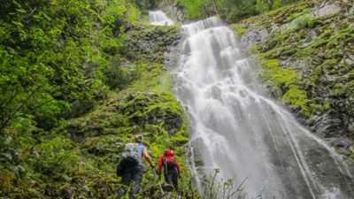
The trail is a good dirt tread with some boardwalks and bridges over marshy areas. It follows the White River along its west bank. Reach Skookum Falls in two miles. Its is the source of Skookum Creek which flows down to the White River. There is a steep, and sometimes muddy, side trail up for a closer view of the falls. Cross Skookum Creek, a usually wide and shallow water crossing. Hike 2 miles to Buck Creek, the site of the old suspension bridge that was taken out by falling trees in the fall storms of 2006. Reach Buck Creek Road is another mile.
notes
- This trail is shared with mountain bikes.
- The bridge at Buck Creek was out as of April of 2010 leaving another water crossing, this one deeper and faster moving but doable.
- In April, 2010, work began to move the trail further uphill away from the banks being eroded when the White River changes course.
Snowshoe Route
Snowshoe upriver from Forest Road 73 at the northern end of the Skookum Flats Trail or downriver from the Buck Creek Road at the southern end. The northern route is about 4 miles round trip and 250 feet of elevation gain, and the southern route is about 6.5 miles round trip and 300 feet of elevation gain.
Information for leaders
Permit information
As of 2017, the Snoqualmie Ranger District considers Mountaineers trips and courses to be "nominal use". Leaders should print and copy this designation letter to show rangers they may see on trail.
- Suitable Activities: Day Hiking, Snowshoeing
- Snowshoeing Category: Basic
- Seasons: Year-round
- Weather: View weather forecast
- Difficulty: Easy
- Length: 11.0 mi
- Elevation Gain: 500 ft
- 2,400 ft
-
Land Manager:
Mount Baker-Snoqualmie National Forest
Snoqualmie Ranger District (MBSNF)
- Parking Permit Required: Northwest Forest Pass
- Recommended Party Size: 12
- Maximum Party Size: 20
- Maximum Route/Place Capacity: 20
- Green Trails Greenwater No. 238
This is a list of titles that represent the variations of trips you can take at this route/place. This includes side trips, extensions and peak combinations. Not seeing a title that fits your trip? Log in and send us updates, images, or resources.
- Skookum Falls
- Skookum Flats & Falls
- Skookum Flats to Buck Creek Road
There are no resources for this route/place. Log in and send us updates, images, or resources.
