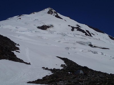
Sherman Peak/Squak Glacier (Mount Baker)
Sherman Peak is a sub peak of Mount Baker with a high point elevation of 10,160 ft. The Squak Glacier is the most direct route, and has moderate slopes, with some steep sections.The route gains nearly 3,600 feet from camp to summit and a total of 6,800 feet. The Approach is popular with snowmobilers in early season. Times: 4-5 hr trail-head to camp, 5-7 hr Camp to summit.
getting there
From I-5 just north of Mount Vernon, go east on SR-20 (North Cascades Highway) and turn left on Baker Lake Road. Continue 12.5 mi to just past the Rocky Creek Bridge, turn left onto Forest Road 12. Go 3.5 mi to Sulfur Creek Road (Forest Road 13). Turn right and follow it 6 mi to its end at Park Butte Trailhead (3,360 ft).
Approach
Cross Sulfur Creek, through Schreiber’s Meadows, through timber, across melt water streams, and up forested slopes (switch backs) to Morovitz Meadows (2 mi). From Upper Meadow take right fork to Baker Pass. Head up on a trail to the crest of the Railroad Grade. Campsites are in trees behind eastern moraine around 5,500 ft, and on ridge east of Railroad Grade at 5,800 ft. For High camps take a rising traverse to the East for 1.25 mi to reach Crag View (6,571 ft)
Ascent RoutE
From high camp make a rising traverse of the Squak Glacier heading for the south ridge of Sherman Peak. Ascend steep snow on the ridge to the summit of Sherman Peak (10,160 ft).
Descent Route
Descend the climbing route, or descend the west ridge to the base of the Roman Wall and continue on down the Easton Glacier.
Trip Profile
| Segment | TIME (HR) | ELEVATION GAIN (FT) |
|---|---|---|
| Seattle to TH | 2.5 | |
| TH to Camp | 4-5 | 3,211 |
| Camp to Summit | 5-7 | 3,589 |
| Summit to Camp | 2-3 | |
| Camp to TH | 2-4 |
EQUIPMENT
Standard glacier equipment including wands.
NOTEs
- The upper snow slope is steep enough to pose problems if icy. In early to mid season, a direct line may be possible
- Can also climb to Grant Peak, the highest summit of Mount Baker.
- The entire route is in the Recreation Area so larger groups are possible.
- There are many crevasses in late season.
- Lower sections of the Squak Glacier are used by classes in Glacier Travel and Crevasse Rescue.
Information for Leaders
- This route is for CLIMBS ONLY. Field trips to this area should be listed on the Mt. Baker Recreation Area Route/Place.
- This route allows multiple bookings. Please check scheduled trips listed below in the "Activities" tab to see if there is another group already booked on the same day. Leaders are expected to contact the leader(s) of existing trips to ensure there are no concerns or conflicts with multiple trips on the same day.
- Suitable Activities: Backcountry Skiing, Climbing
- Climbing Category: Basic Alpine
- Seasons: May, June, July, August, September, October
- Weather: View weather forecast
- View avalanche forecast.
- Difficulty: Technical 3, Strenuous 3, Basic Glacier Climb, M2G Advanced Glacier Ski
- Length: 13.4 mi
- Elevation Gain: 6,800 ft
- 10,160 ft
-
Land Manager:
Mount Baker-Snoqualmie National Forest
Mount Baker National Recreation Area, Mount Baker Ranger District (MBSNF)
- Parking Permit Required: Northwest Forest Pass
- Recommended Party Size: 12
- Maximum Party Size: 24
- Maximum Route/Place Capacity: 12
- USGS Mt Baker
- Green Trails Mount Baker Wilderness Climbing No. 13SX
- USGS Baker Pass
This is a list of titles that represent the variations of trips you can take at this route/place. This includes side trips, extensions and peak combinations. Not seeing a title that fits your trip? Log in and send us updates, images, or resources.
- Mount Baker/Squak Glacier
- Sherman Peak/Squak Glacier
There are no resources for this route/place. Log in and send us updates, images, or resources.
