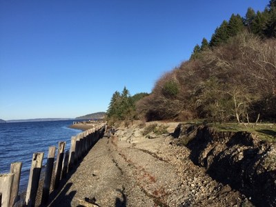
Sequalitchew Canyon & Dupont Bluff
Hike along the railroad grade of the historic DuPont dynamite train on a trail with historic markers that highlight the activities of Native American and early settlers in the area. Then climb from the beach to Wilkes Observatory and DuPont Bluff with views of Puget Sound and the Nisqually Wildlife Refuge. A visit to Edmond Marsh is a good addition to a trip here.
GETTING THERE
Take Exit 118 off of I-5 and turn right onto Center Dr and drive 1.2 miles. Turn left on to Civic Drive, continue 0.1 mile and turn right into the parking lot near DuPont City Hall and Civic Center.
ON THE TRAIL
Sequalitchew Creek Trail
3.2 Miles Round Trip with 225 feet of elevation gain, 225 Ft High Point
The trail follows the railroad grade of the historic DuPont dynamite train along Sequalitchew Creek as it drops down to a pebbled beach at the site of the old DuPont wharf. There are historic markers along the trail which highlight the activities of Native American and early settlers in the area. The trail is partially paved and family friendly.
DuPont Bluff Trail
3.0 Miles Round Trip with 175 feet of elevation gain, 200 Ft High Point
At approximately 1.3 miles down the Sequalitchew Creek trail, the DuPont Bluff trail branches south across a bridge over Sequalitchew creek. The trail climbs up the bluff to reach the site of the historic Wilkes Observatory. The trail continues along the bluff outside of the fence for the Home Course Golf Club. The trail has excellent views of Puget Sound and Nisqually National Wildlife Refuge. The trail ends at Tract I Park the intersection of Ridge View Dr and McNeil St. From here it is possible to loop back to the trailhead using paved city trails along McNeil Street and a connector trail under the power lines. It is also possible to extend your hike several additional miles by continuing on the unpaved city trails that branch off either side of Ridge View Dr just south of Tract I Park.
EDMOND MARSH TRAIL
3.0 MILES ROUND TRIP WITH 50 FEET OF ELEVATION GAIN, 250 FT HIGH POINT
The trail is accessed by going east from the trailhead and crossing under Center Drive. A well maintained path skirts the north edge of the Edmond Marsh before crossing over the marsh on an old railway causeway. The trail continues to the historic village where it ends near the DuPont historical museum.
- Suitable Activities: Day Hiking, Urban Walking
- Seasons: Year-round
- Weather: View weather forecast
- Difficulty: Easy
- Length: 4.0 mi
- Elevation Gain: 200 ft
- Land Manager: City of DuPont
- Parking Permit Required: None
- Recommended Party Size: 12
- Maximum Party Size: 12
- Maximum Route/Place Capacity: 12
- see Land Manager
This is a list of titles that represent the variations of trips you can take at this route/place. This includes side trips, extensions and peak combinations. Not seeing a title that fits your trip? Log in and send us updates, images, or resources.
- Sequalitchew Creek
- Sequalitchew Canyon & Edmond Marsh
- DuPont Bluff Trail
There are no resources for this route/place. Log in and send us updates, images, or resources.
