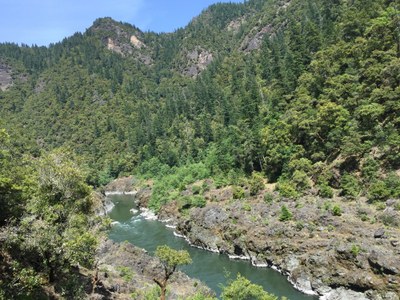
Rogue River National Recreation Trail
Hike or backpack up to 40 miles along the Rogue River. This trail showcases southwestern Oregon's beauty and the spectacular, wild Rogue River, which winds through dramatic rock gorges.
getting there
This trail is can be hiked as an out-and-back from one of its trailheads, or end to end with a car shuttle or hired shuttle service.
- Review the BLM recommended car shuttle routes.
- The Marial trailhead allows overnight parking (GPS coordinates: 42.7181,-123.8809). It is accessed via a long, winding, bumpy, gravel and dirt road. It's about a mile from the Rogue River Ranch, a historic site. There are no gas stations or other services on the long drive to this quiet trailhead, so be sure to travel with plenty of gas, water, and supplies.
- To access the lower section of the Rogue River trail, many hikers begin at Lower Rogue River - Foster Bar Trailhead or Lower Rogue River - Mule Creek Trailhead.
- Other trails wit access the Wild Rogue Wilderness include the Mule Creek Trail #1159 and Clay Hill Trail #1160A.
on the trail
The Rogue River-Siskiyou National Forest stretches from southwestern Oregon into northern California. It includes the southern Cascades and the Siskiyou Mountains. The nearest towns of substantial size are Medford, Ashland, and Grants Pass.
The trail runs for 40 miles between Grave Creek and Big Bend and showcases southwestern Oregon’s beauty while paralleling the Rogue River, an official National Wild and Scenic River. From the north bank of the river, pass through rocky gorges and open meadows, while seeing rafters and boaters float downstream. Full-service private riverside lodges and shuttle services enable hikers and water sports enthusiasts to travel one-way along the river, enjoy a meal, or stay overnight by the river in comfort.
The trail is hikers-only and is closed to motorized vehicles, stock, and bicycles. Part of the trail passes through the Wild Rogue Wilderness. Most of the trail has only moderate elevation gains and losses—hiking the full length of the trail following the river downstream loses elevation overall, and hiking upstream gains about 4,500 feet. It is best done in early-season or late-season, as temperatures can reach 100°F in the river gorges in the middle of summer. Although the trail is open all year, during the rainy season, which typically runs from November to April, the trail sees fewer visitors and experiences more fallen trees, washouts, and rocks. Snow can also fall during these months.
Notes
- Download the Rogue River Guide and trail map from the BLM.
- Additional information, maps, and links to related trails and topics are available at the Rogue River-Siskiyou National Forest's Rogue River National Trail web page.
- The BLM's Rogue River Boaters Guide provides information about suitable riverside beach campsites.
- Traveling cross-country or bushwhacking is not advised since the area is known for an abundance of poison ivy that which on-trail travelers can easily avoid.
- Keep a lookout for rattlesnakes and ticks.
- Hang food or store in bear canisters, because there are black bears in the area.
- Check current fire restrictions prior to visiting this area. When permitted, firepans are required for any campfire within 400 feet of the river's edge. Fire residues must be packed out of the canyon along with all other trash. Firepans prevent scarring and marking of beach sands and rocks by campfires. Better yet, just take a camp stove.
- Suitable Activities: Backpacking, Day Hiking, Trail Running
- Seasons: April, May, June, July, August, September, October
- Weather: View weather forecast
- Difficulty: Moderate
- Length: 40.0 mi
- Elevation Gain: 4,500 ft
-
Land Manager:
Rogue River–Siskiyou National Forest
Gold Beach Ranger District (RRSNF)
- Parking Permit Required: None
- Recommended Party Size: 12
- Maximum Party Size: 12
- Maximum Route/Place Capacity: 12
- see Land Manager
- USGS Mount Reuben, OR
- USGS Bunker Creek, OR
- USGS Kelsey Peak, OR
- USGS Marial, OR
- USGS Illahe, OR
This is a list of titles that represent the variations of trips you can take at this route/place. This includes side trips, extensions and peak combinations. Not seeing a title that fits your trip? Log in and send us updates, images, or resources.
- Rogue River Trail
There are no resources for this route/place. Log in and send us updates, images, or resources.
