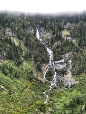
Rock Creek Falls
Hike three miles along the Middle Fork Snoqualmie River with some moderate up and down along an established trail. Then cross the Rock Creek and hike up switchbacks on a steep rocky trail to Rock Creek Falls and then on to Snow Lake in the Alpine Lakes Wilderness. It's 12.6 miles and 2,700 feet of elevation gain.
Getting There
Take Exit 34 off of I-90 and turn north onto 468 Ave SE. In a half mile, turn right onto SE Middle Fork Road (Forest Road 56). Drive 12 miles to the junction with Taylor River Road, turn right onto Forest Road 5620 and drive 5 miles to the Dingford Creek Trailhead (1,500 ft).
On the Trail
Hike southwest from the trailhead, cross the river, and turn right onto the Middle Fork Snoqualmie Trail. Hike 2.7 miles and turn right onto the the Rock Creek Trail. Hike the steep, rocky trail 2.3 miles to Rock Creek Falls. Turn around here or continue on to Snow Lake.
Notes
- It's possible to do a one-way hike up to Snow Lake via Rock Creek and down the Snow Lake Trail to Alpental or visa versa with a car shuttle.
- Suitable Activities: Day Hiking
- Seasons: June, July, August, September, October
- Weather: View weather forecast
- Difficulty: Moderate
- Length: 12.6 mi
- Elevation Gain: 2,700 ft
- 4,100 ft
-
Land Manager:
Mount Baker-Snoqualmie National Forest
Alpine Lakes Wilderness, Snoqualmie Ranger District (MBSNF)
- Parking Permit Required: Northwest Forest Pass
- Recommended Party Size: 12
- Maximum Party Size: 12
- Maximum Route/Place Capacity: 12
- Green Trails Middle Fork Snoqualmie No. 174SX
There are no resources for this route/place. Log in and send us updates, images, or resources.
