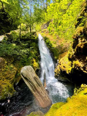
Rock Creek
An unexpectedly fun and scenic half-day creek in the Skokomish River valley. This canyon is rated v3a4II early to mid-season and v3a3II in mid to late summer.
GETTING THERE
From US-101, drive west on Skokomish Valley Road. Near the end of the road, bear right onto Govey Road, heading steeply uphill. The road becomes dirt and Forest Road 23 (aka Forest Road 2353). Park at the pullout just west of the culvert where Forest Road 23 crosses Rock Creek, ~11.4 miles from US-101.
APPROACH
From the pullout, it's a two minute walk along an obvious trail to the bottom of the culvert.
DESCENT
This canyon features numerous jumps. Always check pools for depth/debris before jumping!
- Jump 1: Jump 8 feet or downclimb. There is an abandoned truck upside down in the creek just after this drop.
- Rappel 1/Jump 2: Rappel from a tree DCL (Down Canyon Left) into a narrow hallway by a unique waterfall. This falls has crisscrossing jets of water. Alternatively, jump 12 feet DCR (Down Canyon Right). If jumping, beware of sloping rock underwater on DCL. Keep close to the right side. It is also possible to bypass by carefully downclimbing far DCR.
- Rappel 2/Jump 3: DCL 35 feet from a log that spans the canyon. This log is large and unlikely to fail, but as it is not supported by the opposite canyon wall, it should be used gently as a semi-marginal anchor. Alternatively, jump 15feet DCR.
- Rappel 3/Jump 4: Single bolt above the chute DCR 15 feet. In moderate to high flow, this pothole recirculates behind a veil and can be difficult to escape. It is recommended to set the rope length properly to avoid entanglement in this pool. This can be jumped from DCL. It is an easy jump, but the target is small and must be identified by a teammate from below.
- Jump 5: DCR 12 feet. There are no bolts here, but the varied pool bottom requires someone to check depth. Use two teammates to create a human anchor for the first person down. Alternatively, extend the rope from Rappel 3.
Final Sequence A: The Jump Route
- Rappel 4/Jump 6: The Lagoon DCR 40 feet from a tree into a spectacular pothole. This pothole can be safely jumped from the side (30 feet) the edges slope slightly, but the vast majority of it is upwards of 15 feet deep.
- Rappel 5: DCR from bolts 80 feet out of the pothole, down a sloping mostly dry chute.
Final Sequence B: The Sport Route
- Rappel 4: DCL from bolts 50 feet to a rebelay anchor at the top of the falls and 65 feet to the pool below. This can be rappelled in side flow, or in full flow, at the rappeller's choice.
EXIT
Just after the final sequence is the confluence of Flat Creek, a tributary creek DCR. Scramble up the creek until you reach a small yellow USFS boundary sign. At this point, choose to continue up the creek to the road or turn up a faint use trail in the scree. Once at the road, turn right and walk ¼ mile or less back to the cars.
EQUIPMENT
Standard canyoning gear including webbing, a wrench, and replacement quick links.
TRIP PROFILE
- Rappels: 3-5
- Longest Rappel: 65 feet
- Approach: ~ 200 feet
- Exit: ~0.75 mile
- Time: 3-5 hours total
NOTES
- This canyon is rated v3a4II early to mid-season and v3a3II in mid to late summer.
- Rock Creek passes through a section of Green Diamond Resource Company land that is open to public non-motorized access. No permit is required on this section of GDRC land.
- For more information and recent trip reports from the community, visit the Rock Creek listing on ropewiki.
Information for Leaders
Scheduling
This route allows multiple bookings. Please check scheduled trips listed below in the "Activities" tab to see if there is another group already booked on the same day. Leaders are expected to contact the leader(s) of existing trips to ensure there are no concerns or conflicts, according to The Mountaineers Outdoor Ethics Policy. Please review our Group Size & Multiple Bookings page for guidance.
- Suitable Activities: Canyoning
- Seasons: June, July, August, September
- Weather: View weather forecast
- Length: 1.0 mi
-
Land Manager:
Olympic National Forest
Hood Canal Ranger District (ONF)
- Parking Permit Required: None
- Recommended Party Size: 8
- Maximum Party Size: 12
- Maximum Route/Place Capacity: 24
There are no resources for this route/place. Log in and send us updates, images, or resources.
