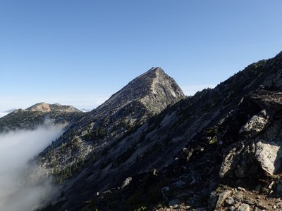
Pasayten Peak
A moderate scramble from Slate Pass near Harts Pass and along Buckskin Ridge Trail to Silver Lake in the Pasayten Wilderness. It's 12 miles round trip from Slate Pass with 3,300 feet of elevation gain. Enjoy flowered meadows with spectacular panoramic views.
getting there
Drive SR 20 east 1.5 miles past Early Winters campground. Turn left and drive 0.4 miles to Mazama. Turn left on Harts Pass Road (No. 9140), which turns into Forest Road 5400 for 20 mi to Harts Pass. Turn right and drive 2 mi to Slate Pass and Buckskin Ridge Trail (No. 498).
approach & ascent
At over 7,000 ft, this scramble starts high and stays high. Hike the Buckskin Ridge Trail about about 4.7 miles from Slate Pass Silver Lake and camp. It's about 1.3 miles from the lake to Pasayten Peak's summit. From Silver Lake, ascend west, then north to the saddle SW of Point 7588. Go through the saddle, then contour northward to the saddle just south of the summit and follow the south ridge to the top. None of the scrambling is very difficult, but most of the terrain above 7,000 ft is boulders and/or loose talus, so it takes more time and energy than you would expect from looking at the map.
notes
- If you arrive early, hike up to Slate Peak for outstanding views in all directions. Slate Peak is the location of an old Air Force radar site.
- Stay at the Harts Pass campground before or after your scramble. While there is sometimes a small creek across the road from the horse hitch and restroom building early in the summer, be aware that there is often no water, especially in late summer, and you must bring your own Harts Pass camping and hiking water and firewood.
- Suitable Activities: Scrambling
- Seasons: July, August, September, October
- Weather: View weather forecast
- Difficulty: Strenuous 3, Technical 3
- Length: 12.0 mi
- Elevation Gain: 3,300 ft
- 7,850 ft
-
Land Manager:
Okanogan-Wenatchee National Forests
Pasayten Wilderness, Methow Valley Ranger District (OWNF)
- Parking Permit Required: Northwest Forest Pass
- Recommended Party Size: 12
- Maximum Party Size: 12
- Maximum Route/Place Capacity: 12
- Green Trails Washington Pass No. 50
- Green Trails Pasayten Peak No. 18
- USGS Slate Peak
- USGS Pasayten Peak
There are no resources for this route/place. Log in and send us updates, images, or resources.
