Olympic Discovery Trail: Olympic Adventure Route
A trail for hiking, mountain biking and horseback riding that runs adjacent to the Olympic Discovery Trail. It starts near the Elwha River and ends at the Spruce Railroad Trailhead at Lake Crescent. There are many options for loop trips along this trail in addition to traveling its entire length.
The Olympic Adventure Route (OAR) has been built by Clallam County volunteers as an adjunct to the Olympic Discovery Trail. It is built for active mountain bikers, hikers, and equestrians. It has 25 miles of double and single track riding over very scenic, hilly, forested terrain. It is a very well-constructed, well-drained, well-maintained, 3 ft wide packed earth trail. The trail is entirely off road except the last 4 miles on the west end, which end which is on old RR grade along the Lyre River and shared with logging access.
from Olympic Discovery Trail
Bikepacking
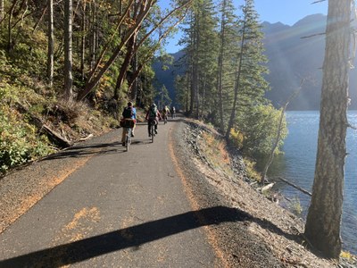
A smooth, mostly non-technical but hilly and very strenuos singletrack route through the Olympic National Forest with scenic views of mountains and Lake Crescent. The section from the end of the single track to Lake Crescent is on a Waterline gravel road. Then from the lake outlet (Lyre River) to Fairholm campground is a 9-mile section on the recently paved Spruce Railroad along the water's edge. Not to be missed is the short detour on foot to Devil's Punchbowl.
Mileage and elevation gain for riding out and back from the west end of the Olympic Adventure Trail to Fairholm Campground is 66 miles and 5,700 feet of elevation gain. Stopping and camping at Log Cabin Resort would that shortens the trip to 25 miles one-way. It can also be done as a loop returning on the Olympic Discovery Trail and Joyce Piedmond Road.
CAMPING
The Log Cabin Resort or Fairholm Campground (reservations strongly recommended and there are closes seasonally). There may be dispersed camping on a parcel of state land west of the Lyre River near the lake's outlet.
WATER
There are many water sources along the route and at Crescent Lake.
- Suitable Activities: Bikepacking, Day Hiking, Trail Running
- Seasons: Year-round
- Weather: View weather forecast
- Difficulty: Moderate/Strenuous, Bikepacking MTB II
- Length: 25.0 mi
- Elevation Gain: 2,800 ft
- 1,400 ft
- Land Manager: Olympic Discovery Trail
- Parking Permit Required: Discover Pass
- Recommended Party Size: 12
- Maximum Party Size: 12
- Maximum Route/Place Capacity: 12
- see Land Manager
- Green Trails Joyce No. 102
- Green Trails Lake Crescent No. 101
This is a list of titles that represent the variations of trips you can take at this route/place. This includes side trips, extensions and peak combinations. Not seeing a title that fits your trip? Log in and send us updates, images, or resources.
- Olympic Adventure Route
- Olympic Adventure Trail
- Olympic Adventure Route: Elwha Valley Overlook
- Olympic Adventure Route: Olympic Skyline
- Olympic Adventure Route: Lake Sutherland, High Divide
- Olympic Adventure Route: Lake Crescent
| Name/Description |
|---|
| Olympic Adventure Route Gaia GPS Track A link to the Gaia GPS route for the Olympic Adventure Route by Emma Agosta posted Jul 15, 2020. |
