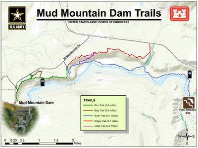
Mud Mountain Dam Trails
Hike along the White River on the Mud Mountain Trails just east of Buckley and Enumlclaw.
getting there
Drive SR-410 6 miles east of Enulclaw, turn right onto Mud Mountain Road, and drive 2.5 miles to the Mud Mountain Dam Recreation Area (1,325 ft).
on the trail
Hike out and back as far along the White River as desired on the Rim, River and Ridge Trails. The Bog Trail makes a nice loop in the middle of the Rim Trail, and Goat Trail connects the River and Ridge Trails. Hike the Vista Trail for a good look at the flood control dam managed by the U.S. Army Corps of Engineers. The recreation area also has a few picnic shelters and a wading pool.
- Suitable Activities: Day Hiking
- Seasons: Year-round
- Weather: View weather forecast
- Difficulty: Easy/Moderate
- Length: 8.0 mi
- Land Manager: U.S. Army Corps of Engineers
- Parking Permit Required: None
- Recommended Party Size: 12
- Maximum Party Size: 12
- Maximum Route/Place Capacity: 12
- Green Trails Enumclaw No. 237
This is a list of titles that represent the variations of trips you can take at this route/place. This includes side trips, extensions and peak combinations. Not seeing a title that fits your trip? Log in and send us updates, images, or resources.
- Mud Mountain Dam Rim Trail
- Mud Mountain Dam Ridge Trail
- Mud Mountain Dam River Trail
- Mud Mountain Dam Rim & Ridge Trails
- Mud Mountain Dam Rim & River Trails
- Mud Mountain Dam Rim & Bog Trails
- Mud Mountain Dam River, Goat & Ridge Trail
- Mud Mountain Dam Vista Trail
There are no resources for this route/place. Log in and send us updates, images, or resources.
