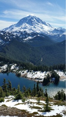
Eunice Lake & Tolmie Peak Lookout
A moderate, 6.4 mile round trip hike with 1,250 feet of elevation gain in Mount Rainier National Park. The trail features alpine forest, flower meadows, a beautiful alpine lake, and a retired fire lookout with a panoramic view.
Emergency closure
As of April 14, 2025, the Fairfax bridge at milepost 11.5 has been closed until further notice. This closes access to Mount Rainier National Park's Mowich Lake and Carbon River entrances. Check WSDOT.com for status.
getting there
Drive SR 165 through Carbonado and the Mount Rainier National Park Entrance to the campground and trailhead at Mowich Lake (4,930 ft).
- Suitable Activities: Day Hiking
- Seasons: July, August, September, October
- Weather: View weather forecast
- Difficulty: Moderate
- Length: 6.4 mi
- Elevation Gain: 1,250 ft
- 5,940 ft
- Land Manager: Mount Rainier National Park
- Parking Permit Required: National Park Entrance Fee
- Recommended Party Size: 12
- Maximum Party Size: 12
- Maximum Route/Place Capacity: 12
- Green Trails Mt Rainier West No. 269
- Green Trails Mount Rainier Wonderland No. 269SX
There are no resources for this route/place. Log in and send us updates, images, or resources.
