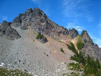
Mount Thompson/East Ridge
A long, challenging scramble to a remote but prominent bell-shaped mountain a few miles from Kendal Catwalk on the Pacific Crest Trail.
driving directions
Drive I-90 east from Seattle to Exit 52, Snoqualmie Pass. Turn left then make the first right on the paved road to the parking area of the Pacific Crest Trail (3,022 ft).
approach & ascent
Hike the Pacific Crest Trail from Snoqualmie Pass to Bumblebee Pass (5,400 ft), approximately 0.5 miles past Ridge Lake where there is camping and water. Bumblebee Pass is a small saddle above Alaska Lake.
Scramble a climbers trail up and over Bumblebee Pass and down (north) into the basin directly in front of Mount Thompson. Snow fills the basin until mid season and water is available throughout the summer. Bivy sites can be found in the western part of the basin.
From the basin angle upward across a rock field toward the east gulley and east ridge of Mount Thompson. Find a climber's trail amongst the heather meadows and follow the ridge to the summit. Expect some Class 4 scrambling at times.
notes
- This peak's name is spelled Thomson on the USGS and Green Trails maps, but Thompson in most guidebooks.
FOr leaders
Permit information
As of 2017, the Snoqualmie Ranger District considers Mountaineers trips and courses to be "nominal use". Leaders should print and copy this designation letter to show rangers they may see on trail or carry a digital copy on their phone.
- Suitable Activities: Climbing, Scrambling
- Climbing Category: Basic Alpine
- Seasons: May, June, July, August, September, October
- Weather: View weather forecast
- Difficulty: Strenuous 5, Technical 5, Basic Alpine Climb
- Length: 18.0 mi
- Elevation Gain: 3,600 ft
- 6,554 ft
-
Land Manager:
Mount Baker-Snoqualmie National Forest
Alpine Lakes Wilderness, Snoqualmie Ranger District (MBSNF)
- Parking Permit Required: Northwest Forest Pass
- Recommended Party Size: 8
- Maximum Party Size: 12
- Maximum Route/Place Capacity: 12
- USGS Chikamin Peak
- Green Trails Snoqualmie Pass Gateway No. 207S
- USGS Snoqualmie Pass
There are no resources for this route/place. Log in and send us updates, images, or resources.
