Mount Pilchuck
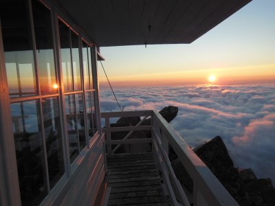
Enjoy stunning views in all directions from the historic fire lookout on top of Mount Pilchcuck. A moderately steep, three-mile hike leads through a former northwest ski area to the summit.
Getting there
From SR-9, turn east onto SR-92 and drive to Granite Falls. Take the second exit onto Quarry Road. After ~2 miles, turn left onto the Mountain Loop Highway and follow it for 11 miles. Turn right onto Mount Pilchuck Road (Forest Road 4220). In summer, continue to the end of the road and the trailhead (3,100 ft). In winter, continue up the road ~1.6 miles to the winter closure gate. Park on the wide areas near the gate being careful not to block the gate and main access road, or any side roads (1,400 ft).
About the Lookout
The historic lookout on the summit has been maintained by volunteers for years. Work on the lookout is always on going. Do join work parties and volunteer to clean, paint, repair and best of all to look at the views.
on the trail
In summer from the trailhead, it's 5.4 miles round trip with 2,200 feet if elevation gain to the summit and lookout. In winter from the gate, it's 11 miles round trip with 4,000 feet of elevation gain.
Note
- The shutters are typically closed for the winter in October. Please follow posted instructions regarding shutters and doors if you plan on visiting during the winter. The shutters are an important part of the Lookout in the winter, when down they protect the windows and create a wall around the lookout making a stable structure. Please do not open the shutters in the winter the heavy snows and wind may break them. Many volunteer hours are spent making, carrying up and replacing them.
Information for LEADERS
scheduling & permits
- Mount Pilchuck is sometimes done as a scramble going up and down the east side or a scramble one way and a hike the other way. To ensure we don't have more than 12 people from The Mountaineers on the same trail on the same day please check the Mount Pilchuck/East Ridge listing and coordinate with the other group.
- If you are scheduling this as a non-course related or non-stewardship activity, please limit your group size to the default party size. The maximum party size is for use by course field trips and stewardship activities only.
- If you are scheduling a course field trip or stewardship activity, please contact our Member Services Team to confirm the activity and any permitting regulations.
- Suitable Activities: Backcountry Skiing, Day Hiking, Scrambling, Snowshoeing
- Snowshoeing Category: Intermediate
- Seasons: Year-round
- Weather: View weather forecast
- View avalanche forecast.
- Difficulty: Moderate
- Length: 5.4 mi
- Elevation Gain: 2,200 ft
- 5,324 ft
-
Land Manager:
Mount Baker-Snoqualmie National Forest
Darrington Ranger District (MBSNF)
- Parking Permit Required: Northwest Forest Pass
- Recommended Party Size: 12
- Maximum Party Size: 30
- Maximum Route/Place Capacity: 30
- Green Trails Mountain Loop Highway No. 111SX
- Green Trails Granite Falls No. 109
- USGS Verlot
This is a list of titles that represent the variations of trips you can take at this route/place. This includes side trips, extensions and peak combinations. Not seeing a title that fits your trip? Log in and send us updates, images, or resources.
- Mount Pilchuck Lookout Maintenance
- Mount Pilchuck/Northwest Face
- Mount Pilchuck: The Gunsight
There are no resources for this route/place. Log in and send us updates, images, or resources.
