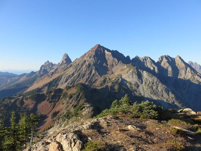
Mount Larrabee
A scramble near Mount Baker of roughly 10 miles and 4,400 feet of elevation gain.
Getting There
Follow US-542 (Mount Baker Highway) past Glacier. Turn left on Forest Road 3065, which is at the highway maintenance facility. Drive 5 miles to small parking area at the Tomyhoi Lake trailhead. A high clearance vehicle can continue to the Twin Lakes trailhead. The last two miles have some tight switchbacks, rocky sections and deep dips.
approach & ascent
From the Twin Lakes trailhead, hike north to Low Pass, then to High Pass. Continue on trail to about 6,400 ft and then traverse left and down to basin, losing 100-200 feet of elevation. Ascend boulder fields, then scree and dirt to the southwest spur at ~6,900 ft. Find the gully system in rocky face. Of two narrow channels (30 feet apart) take the right one. Ascend the narrow, then open gully to broken rock to attain ridge top. Follow the ridge, favoring the west side, to the summit. Most of ridge top has a way trail and the route is partially marked with cairns after leaving the basin, but the cairns may be far apart and the way trail may disappear for long stretches. If you lose cairns or way trail most gullies probably work though some may be more difficult than others.
notes
- Ice axes are useful on the scree.
- Because of rockfall, take helmets and keep your party small (6 or fewer).
- From Tomyhoi Lake it's 12 miles and 4,200 feet of elevation gain.
- From Twin Lakes it's 8 miles and 2,600 feet of elevation gain.
- Suitable Activities: Scrambling
- Seasons: June, July, August, September
- Weather: View weather forecast
- Difficulty: Technical 3, Strenuous 4
- Length: 10.0 mi
- Elevation Gain: 4,400 ft
- 7,861 ft
-
Land Manager:
Mount Baker-Snoqualmie National Forest
Mount Baker Wilderness
- Parking Permit Required: Northwest Forest Pass
- Recommended Party Size: 12
- Maximum Party Size: 12
- Maximum Route/Place Capacity: 12
- USGS Mt Larrabee
- Green Trails Mount Baker Wilderness Climbing No. 13SX
There are no resources for this route/place. Log in and send us updates, images, or resources.
